You are here: Home > Network List > TA - USArray Transportable Network (new EarthScope stations) Stations List
> Station C16K Lisburne Hills, AK, USA > Earthquake Result Viewer
C16K Lisburne Hills, AK, USA - Earthquake Result Viewer
| Earthquake location: |
Tonga Islands |
| Earthquake latitude/longitude: |
-21.1/-174.0 |
| Earthquake time(UTC): |
2019/06/15 (166) 21:56:09 GMT |
| Earthquake Depth: |
10 km |
| Earthquake Magnitude: |
6.1 Mww |
| Earthquake Catalog/Contributor: |
NEIC PDE/us |
|
| Network: |
TA USArray Transportable Network (new EarthScope stations) |
| Station: |
C16K Lisburne Hills, AK, USA |
| Lat/Lon: |
68.27 N/165.34 W |
| Elevation: |
102 m |
|
| Distance: |
89.4 deg |
| Az: |
3.224 deg |
| Baz: |
188.107 deg |
| Ray Param: |
0.04188987 |
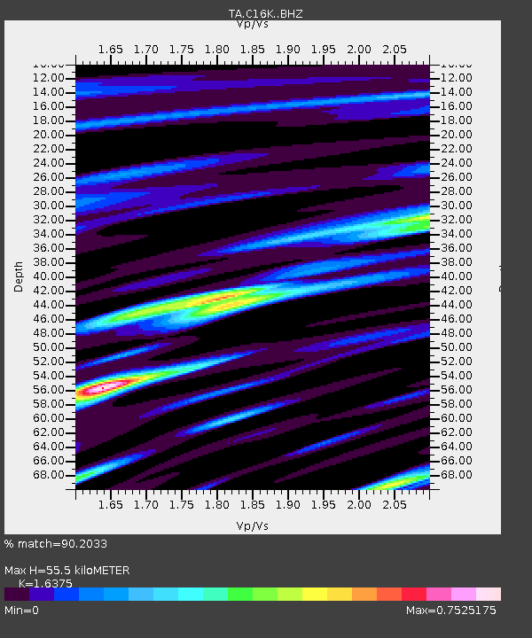
| Estimated Moho Depth: |
55.5 km |
| Estimated Crust Vp/Vs: |
1.64 |
| Assumed Crust Vp: |
5.906 km/s |
| Estimated Crust Vs: |
3.607 km/s |
| Estimated Crust Poisson's Ratio: |
0.20 |
|
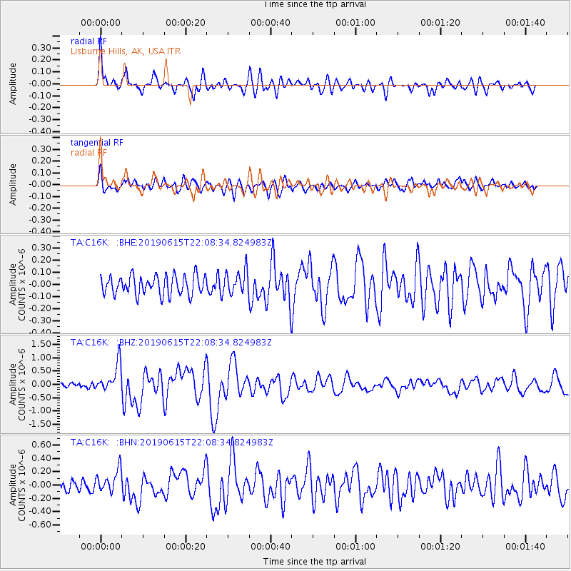
| Radial Match: |
90.2033 % |
| Radial Bump: |
400 |
| Transverse Match: |
81.46997 % |
| Transverse Bump: |
400 |
| SOD ConfigId: |
18369291 |
| Insert Time: |
2019-06-29 22:02:11.966 +0000 |
| GWidth: |
2.5 |
| Max Bumps: |
400 |
| Tol: |
0.001 |
|
Signal To Noise
| Channel | StoN | STA | LTA |
| TA:C16K: :BHZ:20190615T22:08:34.824983Z | 8.148105 | 5.514079E-7 | 6.767314E-8 |
| TA:C16K: :BHN:20190615T22:08:34.824983Z | 2.3167553 | 1.7893242E-7 | 7.723406E-8 |
| TA:C16K: :BHE:20190615T22:08:34.824983Z | 1.2306658 | 9.597378E-8 | 7.7985256E-8 |
| Arrivals |
| Ps | 6.1 SECOND |
| PpPs | 24 SECOND |
| PsPs/PpSs | 30 SECOND |


