You are here: Home > Network List > TA - USArray Transportable Network (new EarthScope stations) Stations List
> Station D17K Noatak River, AK, USA > Earthquake Result Viewer
D17K Noatak River, AK, USA - Earthquake Result Viewer
| Earthquake location: |
Tonga Islands |
| Earthquake latitude/longitude: |
-21.1/-174.0 |
| Earthquake time(UTC): |
2019/06/15 (166) 21:56:09 GMT |
| Earthquake Depth: |
10 km |
| Earthquake Magnitude: |
6.1 Mww |
| Earthquake Catalog/Contributor: |
NEIC PDE/us |
|
| Network: |
TA USArray Transportable Network (new EarthScope stations) |
| Station: |
D17K Noatak River, AK, USA |
| Lat/Lon: |
67.70 N/163.08 W |
| Elevation: |
172 m |
|
| Distance: |
88.9 deg |
| Az: |
4.158 deg |
| Baz: |
190.214 deg |
| Ray Param: |
0.04220733 |
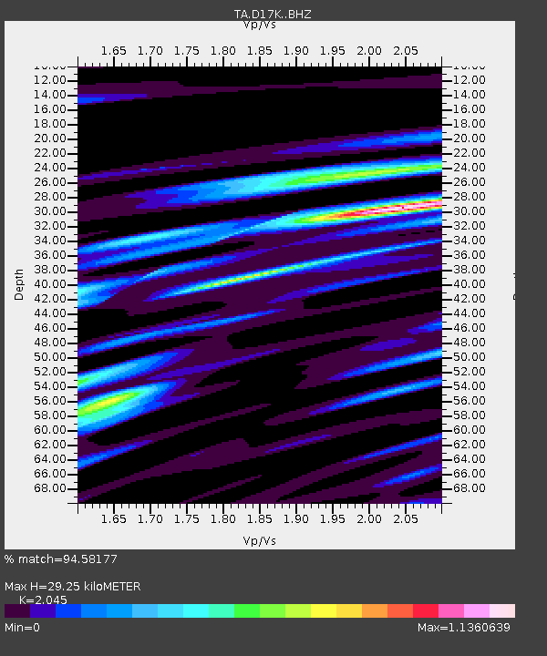
| Estimated Moho Depth: |
29.25 km |
| Estimated Crust Vp/Vs: |
2.05 |
| Assumed Crust Vp: |
6.276 km/s |
| Estimated Crust Vs: |
3.069 km/s |
| Estimated Crust Poisson's Ratio: |
0.34 |
|
| Radial Match: |
94.58177 % |
| Radial Bump: |
391 |
| Transverse Match: |
90.35172 % |
| Transverse Bump: |
400 |
| SOD ConfigId: |
18369291 |
| Insert Time: |
2019-06-29 22:02:16.803 +0000 |
| GWidth: |
2.5 |
| Max Bumps: |
400 |
| Tol: |
0.001 |
|

Signal To Noise
| Channel | StoN | STA | LTA |
| TA:D17K: :BHZ:20190615T22:08:32.80002Z | 12.356593 | 4.816275E-7 | 3.897737E-8 |
| TA:D17K: :BHN:20190615T22:08:32.80002Z | 5.250551 | 1.6768516E-7 | 3.1936676E-8 |
| TA:D17K: :BHE:20190615T22:08:32.80002Z | 0.9852281 | 3.887907E-8 | 3.9461995E-8 |
| Arrivals |
| Ps | 5.0 SECOND |
| PpPs | 14 SECOND |
| PsPs/PpSs | 19 SECOND |


