You are here: Home > Network List > TA - USArray Transportable Network (new EarthScope stations) Stations List
> Station F21K Alatna River, AK, USA > Earthquake Result Viewer
F21K Alatna River, AK, USA - Earthquake Result Viewer

| Earthquake location: |
Tonga Islands |
| Earthquake latitude/longitude: |
-21.1/-174.0 |
| Earthquake time(UTC): |
2019/06/15 (166) 21:56:09 GMT |
| Earthquake Depth: |
10 km |
| Earthquake Magnitude: |
6.1 Mww |
| Earthquake Catalog/Contributor: |
NEIC PDE/us |
|
| Network: |
TA USArray Transportable Network (new EarthScope stations) |
| Station: |
F21K Alatna River, AK, USA |
| Lat/Lon: |
67.22 N/153.48 W |
| Elevation: |
597 m |
|
| Distance: |
89.4 deg |
| Az: |
7.856 deg |
| Baz: |
199.128 deg |
| Ray Param: |
0.04186117 |
| Estimated Moho Depth: |
46.5 km |
| Estimated Crust Vp/Vs: |
1.68 |
| Assumed Crust Vp: |
6.455 km/s |
| Estimated Crust Vs: |
3.842 km/s |
| Estimated Crust Poisson's Ratio: |
0.23 |
|
| Radial Match: |
88.00699 % |
| Radial Bump: |
400 |
| Transverse Match: |
81.20079 % |
| Transverse Bump: |
400 |
| SOD ConfigId: |
18369291 |
| Insert Time: |
2019-06-29 22:02:31.384 +0000 |
| GWidth: |
2.5 |
| Max Bumps: |
400 |
| Tol: |
0.001 |
|
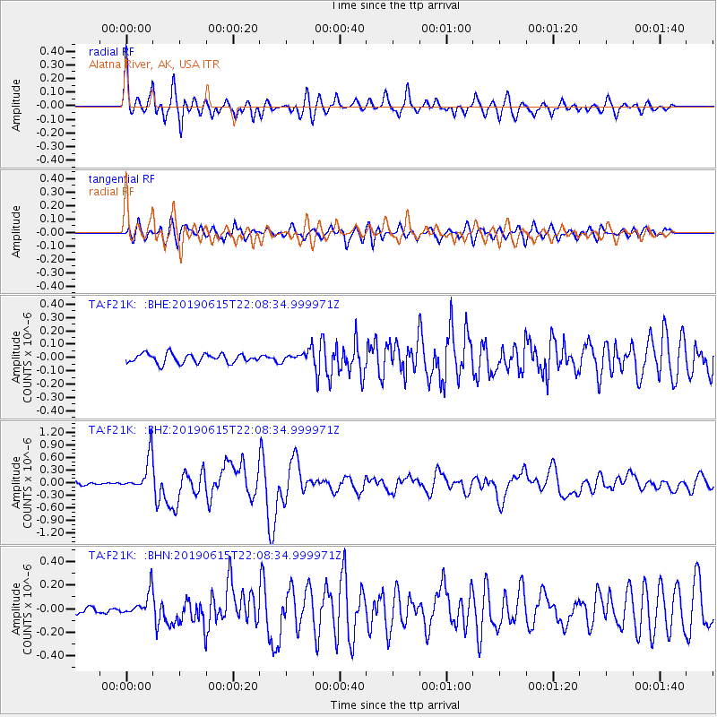
Signal To Noise
| Channel | StoN | STA | LTA |
| TA:F21K: :BHZ:20190615T22:08:34.999971Z | 8.832236 | 4.256522E-7 | 4.8193023E-8 |
| TA:F21K: :BHN:20190615T22:08:34.999971Z | 2.7524986 | 1.05326414E-7 | 3.8265746E-8 |
| TA:F21K: :BHE:20190615T22:08:34.999971Z | 1.2869161 | 4.4514273E-8 | 3.458988E-8 |
| Arrivals |
| Ps | 5.0 SECOND |
| PpPs | 19 SECOND |
| PsPs/PpSs | 24 SECOND |


