You are here: Home > Network List > TA - USArray Transportable Network (new EarthScope stations) Stations List
> Station J18K Innoko River, AK, USA > Earthquake Result Viewer
J18K Innoko River, AK, USA - Earthquake Result Viewer
| Earthquake location: |
Tonga Islands |
| Earthquake latitude/longitude: |
-21.1/-174.0 |
| Earthquake time(UTC): |
2019/06/15 (166) 21:56:09 GMT |
| Earthquake Depth: |
10 km |
| Earthquake Magnitude: |
6.1 Mww |
| Earthquake Catalog/Contributor: |
NEIC PDE/us |
|
| Network: |
TA USArray Transportable Network (new EarthScope stations) |
| Station: |
J18K Innoko River, AK, USA |
| Lat/Lon: |
63.47 N/156.72 W |
| Elevation: |
506 m |
|
| Distance: |
85.4 deg |
| Az: |
7.708 deg |
| Baz: |
196.185 deg |
| Ray Param: |
0.04477929 |
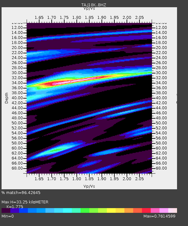
| Estimated Moho Depth: |
33.25 km |
| Estimated Crust Vp/Vs: |
1.77 |
| Assumed Crust Vp: |
6.182 km/s |
| Estimated Crust Vs: |
3.483 km/s |
| Estimated Crust Poisson's Ratio: |
0.27 |
|
| Radial Match: |
96.42645 % |
| Radial Bump: |
366 |
| Transverse Match: |
88.6914 % |
| Transverse Bump: |
400 |
| SOD ConfigId: |
18369291 |
| Insert Time: |
2019-06-29 22:02:56.833 +0000 |
| GWidth: |
2.5 |
| Max Bumps: |
400 |
| Tol: |
0.001 |
|

Signal To Noise
| Channel | StoN | STA | LTA |
| TA:J18K: :BHZ:20190615T22:08:15.725007Z | 10.403755 | 6.6070334E-7 | 6.3506235E-8 |
| TA:J18K: :BHN:20190615T22:08:15.725007Z | 3.330624 | 1.8768252E-7 | 5.6350554E-8 |
| TA:J18K: :BHE:20190615T22:08:15.725007Z | 1.8231989 | 1.00795035E-7 | 5.528472E-8 |
| Arrivals |
| Ps | 4.3 SECOND |
| PpPs | 15 SECOND |
| PsPs/PpSs | 19 SECOND |


