You are here: Home > Network List > TA - USArray Transportable Network (new EarthScope stations) Stations List
> Station 328A Wristen Ranch, Grandfalls, TX, USA > Earthquake Result Viewer
328A Wristen Ranch, Grandfalls, TX, USA - Earthquake Result Viewer

| Earthquake location: |
Hokkaido, Japan Region |
| Earthquake latitude/longitude: |
41.9/143.8 |
| Earthquake time(UTC): |
2008/09/11 (255) 00:20:50 GMT |
| Earthquake Depth: |
25 km |
| Earthquake Magnitude: |
6.1 MB, 7.0 MS, 6.8 MW, 6.8 MW |
| Earthquake Catalog/Contributor: |
WHDF/NEIC |
|
| Network: |
TA USArray Transportable Network (new EarthScope stations) |
| Station: |
328A Wristen Ranch, Grandfalls, TX, USA |
| Lat/Lon: |
31.38 N/102.81 W |
| Elevation: |
755 m |
|
| Distance: |
84.8 deg |
| Az: |
51.995 deg |
| Baz: |
316.538 deg |
| Ray Param: |
0.04519991 |
| Estimated Moho Depth: |
40.75 km |
| Estimated Crust Vp/Vs: |
1.92 |
| Assumed Crust Vp: |
6.121 km/s |
| Estimated Crust Vs: |
3.192 km/s |
| Estimated Crust Poisson's Ratio: |
0.31 |
|
| Radial Match: |
93.23836 % |
| Radial Bump: |
320 |
| Transverse Match: |
84.74245 % |
| Transverse Bump: |
400 |
| SOD ConfigId: |
2560 |
| Insert Time: |
2010-03-06 23:40:52.427 +0000 |
| GWidth: |
2.5 |
| Max Bumps: |
400 |
| Tol: |
0.001 |
|
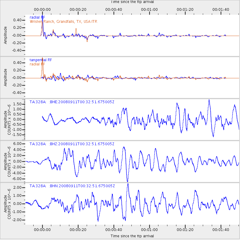
Signal To Noise
| Channel | StoN | STA | LTA |
| TA:328A: :BHZ:20080911T00:32:51.675005Z | 4.6467953 | 8.2686984E-7 | 1.7794412E-7 |
| TA:328A: :BHN:20080911T00:32:51.675005Z | 2.8008378 | 3.8373364E-7 | 1.3700674E-7 |
| TA:328A: :BHE:20080911T00:32:51.675005Z | 0.63719916 | 1.4541428E-7 | 2.282085E-7 |
| Arrivals |
| Ps | 6.2 SECOND |
| PpPs | 19 SECOND |
| PsPs/PpSs | 25 SECOND |


