You are here: Home > Network List > TA - USArray Transportable Network (new EarthScope stations) Stations List
> Station L18K Granite Mountain, AK, USA > Earthquake Result Viewer
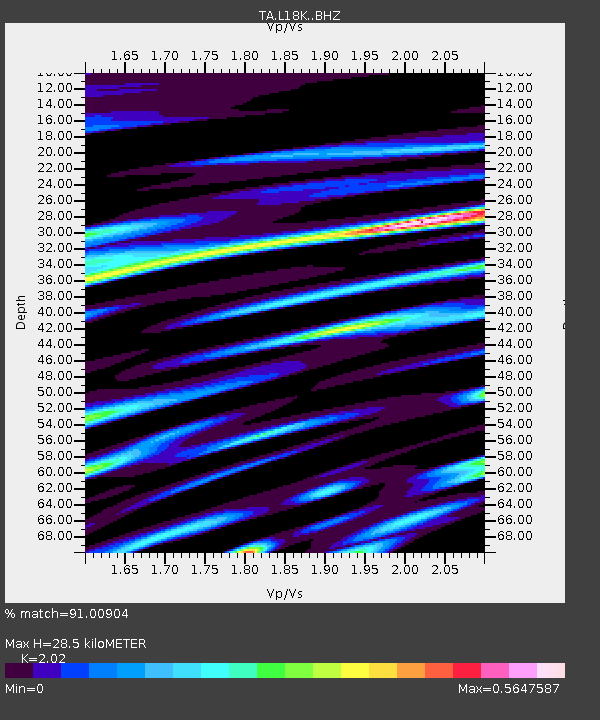
L18K Granite Mountain, AK, USA - Earthquake Result Viewer
| Earthquake location: |
Tonga Islands |
| Earthquake latitude/longitude: |
-21.1/-174.0 |
| Earthquake time(UTC): |
2019/06/15 (166) 21:56:09 GMT |
| Earthquake Depth: |
10 km |
| Earthquake Magnitude: |
6.1 Mww |
| Earthquake Catalog/Contributor: |
NEIC PDE/us |
|
| Network: |
TA USArray Transportable Network (new EarthScope stations) |
| Station: |
L18K Granite Mountain, AK, USA |
| Lat/Lon: |
62.22 N/156.69 W |
| Elevation: |
329 m |
|
| Distance: |
84.2 deg |
| Az: |
8.07 deg |
| Baz: |
196.242 deg |
| Ray Param: |
0.045637228 |
| Estimated Moho Depth: |
28.5 km |
| Estimated Crust Vp/Vs: |
2.02 |
| Assumed Crust Vp: |
6.182 km/s |
| Estimated Crust Vs: |
3.061 km/s |
| Estimated Crust Poisson's Ratio: |
0.34 |
|
| Radial Match: |
91.00904 % |
| Radial Bump: |
400 |
| Transverse Match: |
84.13023 % |
| Transverse Bump: |
400 |
| SOD ConfigId: |
18369291 |
| Insert Time: |
2019-06-29 22:03:05.476 +0000 |
| GWidth: |
2.5 |
| Max Bumps: |
400 |
| Tol: |
0.001 |
|

Signal To Noise
| Channel | StoN | STA | LTA |
| TA:L18K: :BHZ:20190615T22:08:09.725007Z | 3.7850976 | 2.899731E-7 | 7.660914E-8 |
| TA:L18K: :BHN:20190615T22:08:09.725007Z | 1.2522722 | 8.140298E-8 | 6.500422E-8 |
| TA:L18K: :BHE:20190615T22:08:09.725007Z | 1.202764 | 9.137101E-8 | 7.596753E-8 |
| Arrivals |
| Ps | 4.8 SECOND |
| PpPs | 14 SECOND |
| PsPs/PpSs | 18 SECOND |


