You are here: Home > Network List > TA - USArray Transportable Network (new EarthScope stations) Stations List
> Station M11K Mekoryuk, AK, USA > Earthquake Result Viewer
M11K Mekoryuk, AK, USA - Earthquake Result Viewer
| Earthquake location: |
Tonga Islands |
| Earthquake latitude/longitude: |
-21.1/-174.0 |
| Earthquake time(UTC): |
2019/06/15 (166) 21:56:09 GMT |
| Earthquake Depth: |
10 km |
| Earthquake Magnitude: |
6.1 Mww |
| Earthquake Catalog/Contributor: |
NEIC PDE/us |
|
| Network: |
TA USArray Transportable Network (new EarthScope stations) |
| Station: |
M11K Mekoryuk, AK, USA |
| Lat/Lon: |
60.38 N/166.20 W |
| Elevation: |
3.0 m |
|
| Distance: |
81.5 deg |
| Az: |
3.924 deg |
| Baz: |
187.389 deg |
| Ray Param: |
0.047555137 |
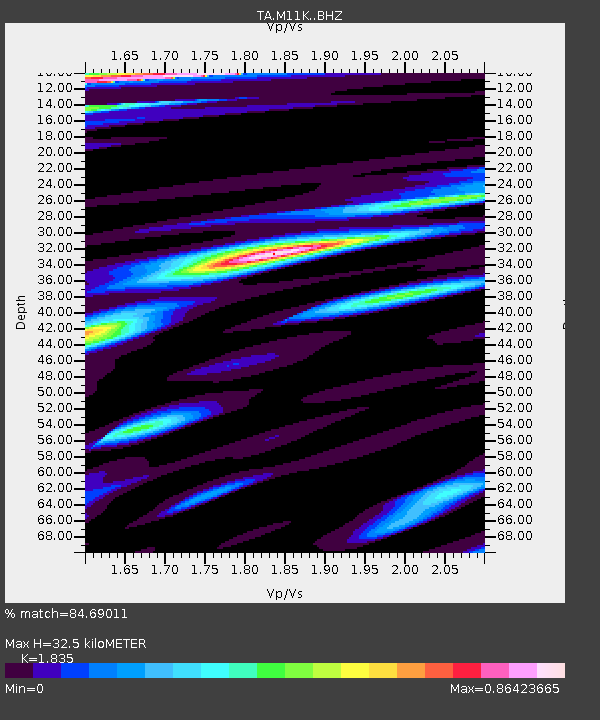
| Estimated Moho Depth: |
32.5 km |
| Estimated Crust Vp/Vs: |
1.84 |
| Assumed Crust Vp: |
6.134 km/s |
| Estimated Crust Vs: |
3.343 km/s |
| Estimated Crust Poisson's Ratio: |
0.29 |
|
| Radial Match: |
84.69011 % |
| Radial Bump: |
400 |
| Transverse Match: |
72.930275 % |
| Transverse Bump: |
400 |
| SOD ConfigId: |
18369291 |
| Insert Time: |
2019-06-29 22:03:08.894 +0000 |
| GWidth: |
2.5 |
| Max Bumps: |
400 |
| Tol: |
0.001 |
|

Signal To Noise
| Channel | StoN | STA | LTA |
| TA:M11K: :BHZ:20190615T22:07:55.574983Z | 3.4765615 | 4.543633E-7 | 1.306933E-7 |
| TA:M11K: :BHN:20190615T22:07:55.574983Z | 1.0001023 | 1.7553968E-7 | 1.7552173E-7 |
| TA:M11K: :BHE:20190615T22:07:55.574983Z | 1.3314816 | 2.7729848E-7 | 2.0826312E-7 |
| Arrivals |
| Ps | 4.5 SECOND |
| PpPs | 15 SECOND |
| PsPs/PpSs | 19 SECOND |


