You are here: Home > Network List > TA - USArray Transportable Network (new EarthScope stations) Stations List
> Station N16K Nishlik Lake, AK, USA > Earthquake Result Viewer
N16K Nishlik Lake, AK, USA - Earthquake Result Viewer
| Earthquake location: |
Tonga Islands |
| Earthquake latitude/longitude: |
-21.1/-174.0 |
| Earthquake time(UTC): |
2019/06/15 (166) 21:56:09 GMT |
| Earthquake Depth: |
10 km |
| Earthquake Magnitude: |
6.1 Mww |
| Earthquake Catalog/Contributor: |
NEIC PDE/us |
|
| Network: |
TA USArray Transportable Network (new EarthScope stations) |
| Station: |
N16K Nishlik Lake, AK, USA |
| Lat/Lon: |
60.47 N/158.77 W |
| Elevation: |
582 m |
|
| Distance: |
82.3 deg |
| Az: |
7.562 deg |
| Baz: |
194.359 deg |
| Ray Param: |
0.047006506 |
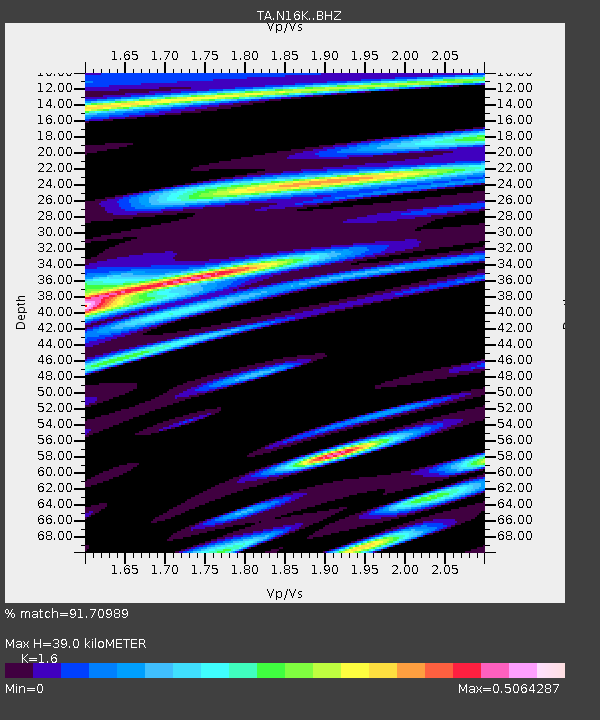
| Estimated Moho Depth: |
39.0 km |
| Estimated Crust Vp/Vs: |
1.60 |
| Assumed Crust Vp: |
6.276 km/s |
| Estimated Crust Vs: |
3.922 km/s |
| Estimated Crust Poisson's Ratio: |
0.18 |
|
| Radial Match: |
91.70989 % |
| Radial Bump: |
400 |
| Transverse Match: |
77.79012 % |
| Transverse Bump: |
400 |
| SOD ConfigId: |
18369291 |
| Insert Time: |
2019-06-29 22:03:19.035 +0000 |
| GWidth: |
2.5 |
| Max Bumps: |
400 |
| Tol: |
0.001 |
|

Signal To Noise
| Channel | StoN | STA | LTA |
| TA:N16K: :BHZ:20190615T22:07:59.699983Z | 5.382721 | 5.667686E-7 | 1.0529407E-7 |
| TA:N16K: :BHN:20190615T22:07:59.699983Z | 3.9872413 | 2.2703743E-7 | 5.694098E-8 |
| TA:N16K: :BHE:20190615T22:07:59.699983Z | 1.3954972 | 1.06609086E-7 | 7.6395054E-8 |
| Arrivals |
| Ps | 3.8 SECOND |
| PpPs | 16 SECOND |
| PsPs/PpSs | 20 SECOND |


