You are here: Home > Network List > TA - USArray Transportable Network (new EarthScope stations) Stations List
> Station P17K Kvichak River, AK, USA > Earthquake Result Viewer
P17K Kvichak River, AK, USA - Earthquake Result Viewer
| Earthquake location: |
Tonga Islands |
| Earthquake latitude/longitude: |
-21.1/-174.0 |
| Earthquake time(UTC): |
2019/06/15 (166) 21:56:09 GMT |
| Earthquake Depth: |
10 km |
| Earthquake Magnitude: |
6.1 Mww |
| Earthquake Catalog/Contributor: |
NEIC PDE/us |
|
| Network: |
TA USArray Transportable Network (new EarthScope stations) |
| Station: |
P17K Kvichak River, AK, USA |
| Lat/Lon: |
59.20 N/156.44 W |
| Elevation: |
91 m |
|
| Distance: |
81.3 deg |
| Az: |
9.053 deg |
| Baz: |
196.583 deg |
| Ray Param: |
0.04765316 |
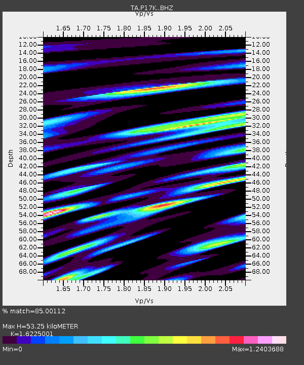
| Estimated Moho Depth: |
53.25 km |
| Estimated Crust Vp/Vs: |
1.62 |
| Assumed Crust Vp: |
6.276 km/s |
| Estimated Crust Vs: |
3.868 km/s |
| Estimated Crust Poisson's Ratio: |
0.19 |
|
| Radial Match: |
85.00112 % |
| Radial Bump: |
400 |
| Transverse Match: |
79.3126 % |
| Transverse Bump: |
400 |
| SOD ConfigId: |
18369291 |
| Insert Time: |
2019-06-29 22:03:28.985 +0000 |
| GWidth: |
2.5 |
| Max Bumps: |
400 |
| Tol: |
0.001 |
|
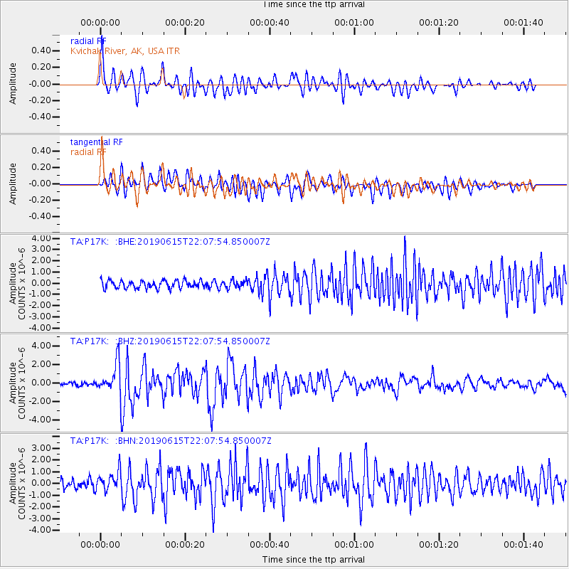
Signal To Noise
| Channel | StoN | STA | LTA |
| TA:P17K: :BHZ:20190615T22:07:54.850007Z | 8.333799 | 1.6677627E-6 | 2.0012034E-7 |
| TA:P17K: :BHN:20190615T22:07:54.850007Z | 2.178144 | 8.283651E-7 | 3.8030777E-7 |
| TA:P17K: :BHE:20190615T22:07:54.850007Z | 0.98524415 | 3.429485E-7 | 3.480848E-7 |
| Arrivals |
| Ps | 5.4 SECOND |
| PpPs | 22 SECOND |
| PsPs/PpSs | 27 SECOND |


