You are here: Home > Network List > TA - USArray Transportable Network (new EarthScope stations) Stations List
> Station 328A Wristen Ranch, Grandfalls, TX, USA > Earthquake Result Viewer
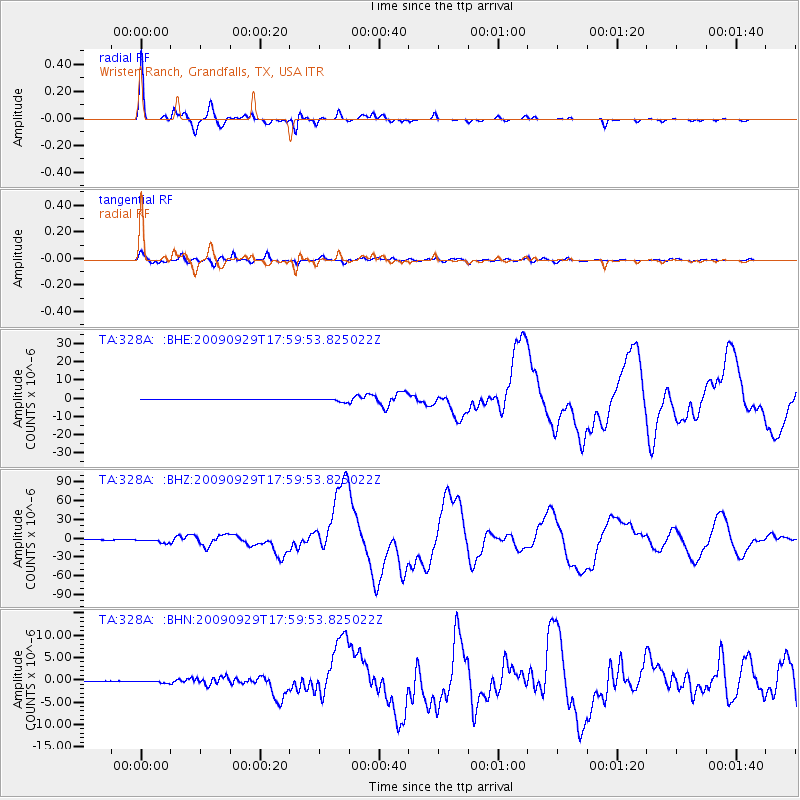
328A Wristen Ranch, Grandfalls, TX, USA - Earthquake Result Viewer

| Earthquake location: |
Samoa Islands Region |
| Earthquake latitude/longitude: |
-15.5/-172.1 |
| Earthquake time(UTC): |
2009/09/29 (272) 17:48:10 GMT |
| Earthquake Depth: |
18 km |
| Earthquake Magnitude: |
7.1 MB, 8.1 MS, 8.1 MW, 8.0 MW |
| Earthquake Catalog/Contributor: |
WHDF/NEIC |
|
| Network: |
TA USArray Transportable Network (new EarthScope stations) |
| Station: |
328A Wristen Ranch, Grandfalls, TX, USA |
| Lat/Lon: |
31.38 N/102.81 W |
| Elevation: |
755 m |
|
| Distance: |
81.1 deg |
| Az: |
54.062 deg |
| Baz: |
245.884 deg |
| Ray Param: |
0.047786586 |
| Estimated Moho Depth: |
69.0 km |
| Estimated Crust Vp/Vs: |
2.03 |
| Assumed Crust Vp: |
6.121 km/s |
| Estimated Crust Vs: |
3.015 km/s |
| Estimated Crust Poisson's Ratio: |
0.34 |
|
| Radial Match: |
98.91084 % |
| Radial Bump: |
260 |
| Transverse Match: |
90.483116 % |
| Transverse Bump: |
400 |
| SOD ConfigId: |
2622 |
| Insert Time: |
2010-03-06 23:41:09.649 +0000 |
| GWidth: |
2.5 |
| Max Bumps: |
400 |
| Tol: |
0.001 |
|
Signal To Noise
| Channel | StoN | STA | LTA |
| TA:328A: :BHZ:20090929T17:59:53.825022Z | 20.425125 | 2.9797764E-6 | 1.4588778E-7 |
| TA:328A: :BHN:20090929T17:59:53.825022Z | 3.3413987 | 2.4069456E-7 | 7.203408E-8 |
| TA:328A: :BHE:20090929T17:59:53.825022Z | 13.005663 | 9.871902E-7 | 7.5904644E-8 |
| Arrivals |
| Ps | 12 SECOND |
| PpPs | 33 SECOND |
| PsPs/PpSs | 45 SECOND |


