You are here: Home > Network List > US - United States National Seismic Network Stations List
> Station NEW Newport, Washington, USA > Earthquake Result Viewer
NEW Newport, Washington, USA - Earthquake Result Viewer
| Earthquake location: |
Tonga Islands |
| Earthquake latitude/longitude: |
-21.1/-174.0 |
| Earthquake time(UTC): |
2019/06/15 (166) 21:56:09 GMT |
| Earthquake Depth: |
10 km |
| Earthquake Magnitude: |
6.1 Mww |
| Earthquake Catalog/Contributor: |
NEIC PDE/us |
|
| Network: |
US United States National Seismic Network |
| Station: |
NEW Newport, Washington, USA |
| Lat/Lon: |
48.26 N/117.12 W |
| Elevation: |
760 m |
|
| Distance: |
85.8 deg |
| Az: |
34.15 deg |
| Baz: |
231.652 deg |
| Ray Param: |
0.044525824 |
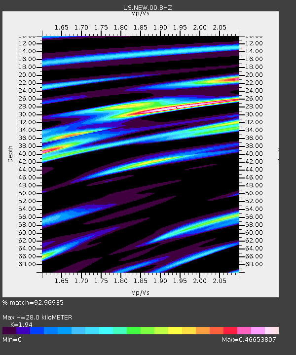
| Estimated Moho Depth: |
28.0 km |
| Estimated Crust Vp/Vs: |
1.94 |
| Assumed Crust Vp: |
6.571 km/s |
| Estimated Crust Vs: |
3.387 km/s |
| Estimated Crust Poisson's Ratio: |
0.32 |
|
| Radial Match: |
92.96935 % |
| Radial Bump: |
400 |
| Transverse Match: |
90.59703 % |
| Transverse Bump: |
400 |
| SOD ConfigId: |
18369291 |
| Insert Time: |
2019-06-29 22:04:21.322 +0000 |
| GWidth: |
2.5 |
| Max Bumps: |
400 |
| Tol: |
0.001 |
|

Signal To Noise
| Channel | StoN | STA | LTA |
| US:NEW:00:BHZ:20190615T22:08:17.475007Z | 2.5639045 | 1.59227E-7 | 6.2103325E-8 |
| US:NEW:00:BH1:20190615T22:08:17.475007Z | 0.8045335 | 3.2182715E-8 | 4.000171E-8 |
| US:NEW:00:BH2:20190615T22:08:17.475007Z | 0.8453601 | 4.3898048E-8 | 5.1928225E-8 |
| Arrivals |
| Ps | 4.1 SECOND |
| PpPs | 12 SECOND |
| PsPs/PpSs | 16 SECOND |


