You are here: Home > Network List > GS - US Geological Survey Networks Stations List
> Station DEC05 Decatur Surface Seismic Site, Decatur, IL, USA > Earthquake Result Viewer
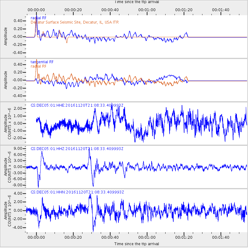
DEC05 Decatur Surface Seismic Site, Decatur, IL, USA - Earthquake Result Viewer
*The percent match for this event was below the threshold and hence no stack was calculated.
| Earthquake location: |
San Juan Province, Argentina |
| Earthquake latitude/longitude: |
-31.6/-68.8 |
| Earthquake time(UTC): |
2016/11/20 (325) 20:57:43 GMT |
| Earthquake Depth: |
116 km |
| Earthquake Magnitude: |
6.4 MWP, 6.5 MWB |
| Earthquake Catalog/Contributor: |
NEIC PDE/NEIC COMCAT |
|
| Network: |
GS US Geological Survey Networks |
| Station: |
DEC05 Decatur Surface Seismic Site, Decatur, IL, USA |
| Lat/Lon: |
39.87 N/88.87 W |
| Elevation: |
216 m |
|
| Distance: |
73.6 deg |
| Az: |
343.991 deg |
| Baz: |
162.204 deg |
| Ray Param: |
$rayparam |
*The percent match for this event was below the threshold and hence was not used in the summary stack. |
|
| Radial Match: |
73.464874 % |
| Radial Bump: |
400 |
| Transverse Match: |
53.166794 % |
| Transverse Bump: |
400 |
| SOD ConfigId: |
1858631 |
| Insert Time: |
2016-12-04 21:00:19.685 +0000 |
| GWidth: |
2.5 |
| Max Bumps: |
400 |
| Tol: |
0.001 |
|
Signal To Noise
| Channel | StoN | STA | LTA |
| GS:DEC05:01:HHZ:20161120T21:08:33.409993Z | 14.861473 | 4.413938E-6 | 2.970054E-7 |
| GS:DEC05:01:HHN:20161120T21:08:33.409993Z | 3.1182485 | 1.7099799E-6 | 5.483783E-7 |
| GS:DEC05:01:HHE:20161120T21:08:33.409993Z | 1.8707007 | 1.0299957E-6 | 5.5059354E-7 |
| Arrivals |
| Ps | |
| PpPs | |
| PsPs/PpSs | |


