You are here: Home > Network List > TA - USArray Transportable Network (new EarthScope stations) Stations List
> Station 328A Wristen Ranch, Grandfalls, TX, USA > Earthquake Result Viewer
328A Wristen Ranch, Grandfalls, TX, USA - Earthquake Result Viewer
| Earthquake location: |
Southern Peru |
| Earthquake latitude/longitude: |
-15.0/-70.4 |
| Earthquake time(UTC): |
2009/07/12 (193) 06:12:47 GMT |
| Earthquake Depth: |
199 km |
| Earthquake Magnitude: |
5.7 MB, 6.1 MW, 6.1 MW |
| Earthquake Catalog/Contributor: |
WHDF/NEIC |
|
| Network: |
TA USArray Transportable Network (new EarthScope stations) |
| Station: |
328A Wristen Ranch, Grandfalls, TX, USA |
| Lat/Lon: |
31.38 N/102.81 W |
| Elevation: |
755 m |
|
| Distance: |
55.6 deg |
| Az: |
326.318 deg |
| Baz: |
141.208 deg |
| Ray Param: |
0.063986085 |
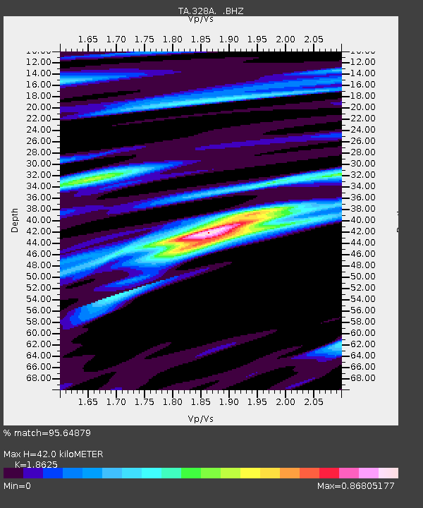
| Estimated Moho Depth: |
42.0 km |
| Estimated Crust Vp/Vs: |
1.86 |
| Assumed Crust Vp: |
6.121 km/s |
| Estimated Crust Vs: |
3.286 km/s |
| Estimated Crust Poisson's Ratio: |
0.30 |
|
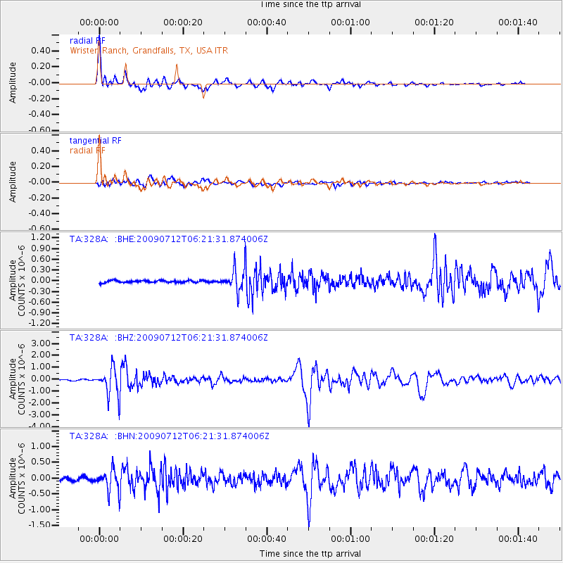
| Radial Match: |
95.64879 % |
| Radial Bump: |
383 |
| Transverse Match: |
89.3284 % |
| Transverse Bump: |
400 |
| SOD ConfigId: |
2648 |
| Insert Time: |
2010-03-06 23:41:38.682 +0000 |
| GWidth: |
2.5 |
| Max Bumps: |
400 |
| Tol: |
0.001 |
|
Signal To Noise
| Channel | StoN | STA | LTA |
| TA:328A: :BHZ:20090712T06:21:31.874006Z | 23.210573 | 1.1695269E-6 | 5.0387676E-8 |
| TA:328A: :BHN:20090712T06:21:31.874006Z | 6.641972 | 3.414245E-7 | 5.1404086E-8 |
| TA:328A: :BHE:20090712T06:21:31.874006Z | 11.030042 | 3.288725E-7 | 2.9816068E-8 |
| Arrivals |
| Ps | 6.2 SECOND |
| PpPs | 19 SECOND |
| PsPs/PpSs | 25 SECOND |


