You are here: Home > Network List > TA - USArray Transportable Network (new EarthScope stations) Stations List
> Station 328A Wristen Ranch, Grandfalls, TX, USA > Earthquake Result Viewer
328A Wristen Ranch, Grandfalls, TX, USA - Earthquake Result Viewer
| Earthquake location: |
Kodiak Island Region, Alaska |
| Earthquake latitude/longitude: |
56.5/-152.7 |
| Earthquake time(UTC): |
2009/03/30 (089) 07:13:07 GMT |
| Earthquake Depth: |
21 km |
| Earthquake Magnitude: |
5.9 MB, 5.9 MS, 5.9 MW, 5.9 MW |
| Earthquake Catalog/Contributor: |
WHDF/NEIC |
|
| Network: |
TA USArray Transportable Network (new EarthScope stations) |
| Station: |
328A Wristen Ranch, Grandfalls, TX, USA |
| Lat/Lon: |
31.38 N/102.81 W |
| Elevation: |
755 m |
|
| Distance: |
42.6 deg |
| Az: |
104.672 deg |
| Baz: |
321.211 deg |
| Ray Param: |
0.0730671 |
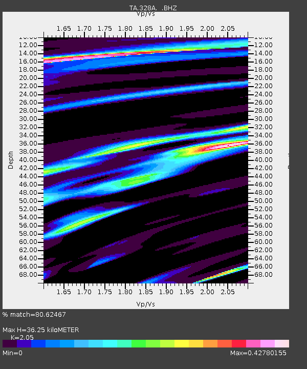
| Estimated Moho Depth: |
36.25 km |
| Estimated Crust Vp/Vs: |
2.05 |
| Assumed Crust Vp: |
6.121 km/s |
| Estimated Crust Vs: |
2.986 km/s |
| Estimated Crust Poisson's Ratio: |
0.34 |
|
| Radial Match: |
80.62467 % |
| Radial Bump: |
311 |
| Transverse Match: |
65.34043 % |
| Transverse Bump: |
322 |
| SOD ConfigId: |
2658 |
| Insert Time: |
2010-03-06 23:41:40.876 +0000 |
| GWidth: |
2.5 |
| Max Bumps: |
400 |
| Tol: |
0.001 |
|

Signal To Noise
| Channel | StoN | STA | LTA |
| TA:328A: :BHZ:20090330T07:20:30.850007Z | 4.2536044 | 8.9323237E-7 | 2.0999424E-7 |
| TA:328A: :BHN:20090330T07:20:30.850007Z | 3.0944297 | 4.028893E-7 | 1.3019823E-7 |
| TA:328A: :BHE:20090330T07:20:30.850007Z | 2.9594102 | 3.6378376E-7 | 1.2292442E-7 |
| Arrivals |
| Ps | 6.6 SECOND |
| PpPs | 17 SECOND |
| PsPs/PpSs | 24 SECOND |


