You are here: Home > Network List > TA - USArray Transportable Network (new EarthScope stations) Stations List
> Station 328A Wristen Ranch, Grandfalls, TX, USA > Earthquake Result Viewer
328A Wristen Ranch, Grandfalls, TX, USA - Earthquake Result Viewer
| Earthquake location: |
Central Mid-Atlantic Ridge |
| Earthquake latitude/longitude: |
7.3/-34.9 |
| Earthquake time(UTC): |
2008/05/23 (144) 19:35:34 GMT |
| Earthquake Depth: |
9.0 km |
| Earthquake Magnitude: |
6.0 MB, 6.4 MS, 6.5 MW, 6.5 MW |
| Earthquake Catalog/Contributor: |
WHDF/NEIC |
|
| Network: |
TA USArray Transportable Network (new EarthScope stations) |
| Station: |
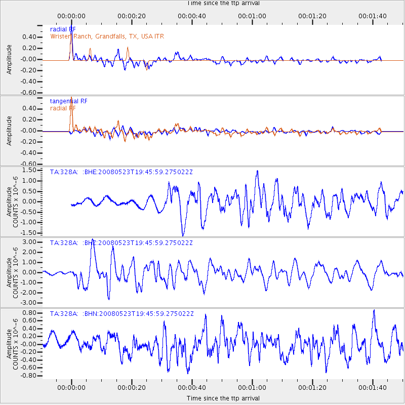
328A Wristen Ranch, Grandfalls, TX, USA |
| Lat/Lon: |
31.38 N/102.81 W |
| Elevation: |
755 m |
|
| Distance: |
67.4 deg |
| Az: |
300.85 deg |
| Baz: |
95.292 deg |
| Ray Param: |
0.056993164 |
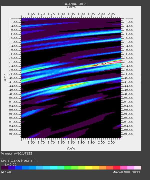
| Estimated Moho Depth: |
32.5 km |
| Estimated Crust Vp/Vs: |
2.02 |
| Assumed Crust Vp: |
6.121 km/s |
| Estimated Crust Vs: |
3.03 km/s |
| Estimated Crust Poisson's Ratio: |
0.34 |
|
| Radial Match: |
80.19322 % |
| Radial Bump: |
400 |
| Transverse Match: |
62.34231 % |
| Transverse Bump: |
400 |
| SOD ConfigId: |
2504 |
| Insert Time: |
2010-03-06 23:41:47.566 +0000 |
| GWidth: |
2.5 |
| Max Bumps: |
400 |
| Tol: |
0.001 |
|
Signal To Noise
| Channel | StoN | STA | LTA |
| TA:328A: :BHZ:20080523T19:45:59.275022Z | 4.4726367 | 8.562789E-7 | 1.9144835E-7 |
| TA:328A: :BHN:20080523T19:45:59.275022Z | 1.5086172 | 2.3290897E-7 | 1.5438575E-7 |
| TA:328A: :BHE:20080523T19:45:59.275022Z | 3.4407358 | 5.2483665E-7 | 1.5253617E-7 |
| Arrivals |
| Ps | 5.6 SECOND |
| PpPs | 16 SECOND |
| PsPs/PpSs | 21 SECOND |


