You are here: Home > Network List > AU - Australian Seismological Centre Stations List
> Station XMIS Christmas Island Grants Well > Earthquake Result Viewer
XMIS Christmas Island Grants Well - Earthquake Result Viewer
| Earthquake location: |
Kermadec Islands Region |
| Earthquake latitude/longitude: |
-31.0/-177.4 |
| Earthquake time(UTC): |
2019/06/15 (166) 22:54:55 GMT |
| Earthquake Depth: |
10 km |
| Earthquake Magnitude: |
7.4 Mi |
| Earthquake Catalog/Contributor: |
NEIC PDE/pt |
|
| Network: |
AU Australian Seismological Centre |
| Station: |
XMIS Christmas Island Grants Well |
| Lat/Lon: |
10.48 S/105.65 E |
| Elevation: |
210 m |
|
| Distance: |
73.5 deg |
| Az: |
267.546 deg |
| Baz: |
119.315 deg |
| Ray Param: |
0.05294474 |
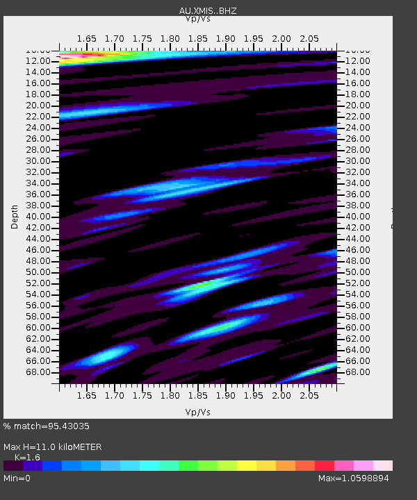
| Estimated Moho Depth: |
11.0 km |
| Estimated Crust Vp/Vs: |
1.60 |
| Assumed Crust Vp: |
4.157 km/s |
| Estimated Crust Vs: |
2.598 km/s |
| Estimated Crust Poisson's Ratio: |
0.18 |
|
| Radial Match: |
95.43035 % |
| Radial Bump: |
399 |
| Transverse Match: |
76.914474 % |
| Transverse Bump: |
400 |
| SOD ConfigId: |
18369291 |
| Insert Time: |
2019-06-29 22:56:08.346 +0000 |
| GWidth: |
2.5 |
| Max Bumps: |
400 |
| Tol: |
0.001 |
|

Signal To Noise
| Channel | StoN | STA | LTA |
| AU:XMIS: :BHZ:20190615T23:05:56.593994Z | 13.800392 | 1.1265334E-5 | 8.163054E-7 |
| AU:XMIS: :BHN:20190615T23:05:56.593994Z | 3.3040974 | 2.0317461E-6 | 6.1491716E-7 |
| AU:XMIS: :BHE:20190615T23:05:56.593994Z | 6.521518 | 5.5026094E-6 | 8.43762E-7 |
| Arrivals |
| Ps | 1.6 SECOND |
| PpPs | 6.8 SECOND |
| PsPs/PpSs | 8.4 SECOND |


