You are here: Home > Network List > AV - Alaska Volcano Observatory Stations List
> Station AHB Akutan Harbor, Akutan Volcano, Alaska > Earthquake Result Viewer
AHB Akutan Harbor, Akutan Volcano, Alaska - Earthquake Result Viewer
| Earthquake location: |
Kermadec Islands Region |
| Earthquake latitude/longitude: |
-31.0/-177.4 |
| Earthquake time(UTC): |
2019/06/15 (166) 22:54:55 GMT |
| Earthquake Depth: |
10 km |
| Earthquake Magnitude: |
7.4 Mi |
| Earthquake Catalog/Contributor: |
NEIC PDE/pt |
|
| Network: |
AV Alaska Volcano Observatory |
| Station: |
AHB Akutan Harbor, Akutan Volcano, Alaska |
| Lat/Lon: |
54.11 N/165.82 W |
| Elevation: |
447 m |
|
| Distance: |
85.4 deg |
| Az: |
6.818 deg |
| Baz: |
189.967 deg |
| Ray Param: |
0.04479815 |
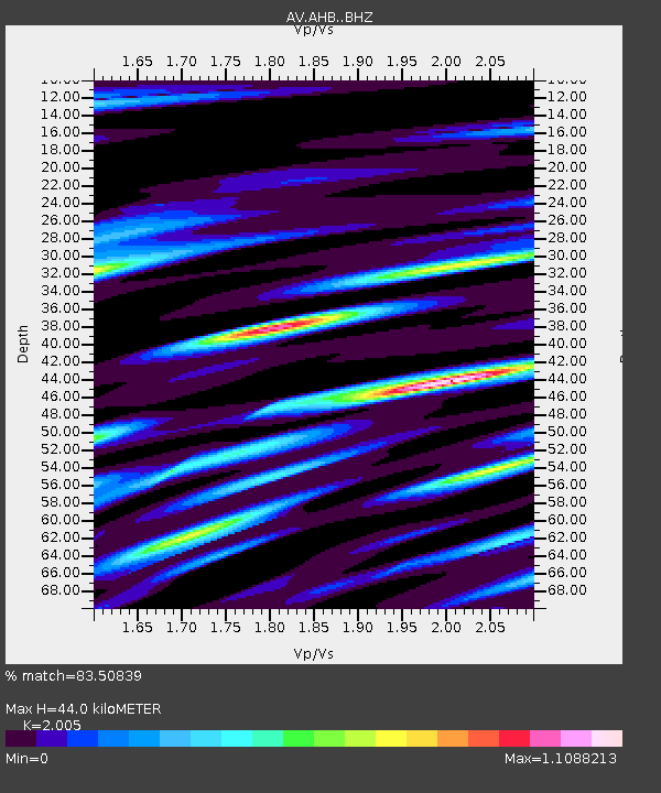
| Estimated Moho Depth: |
44.0 km |
| Estimated Crust Vp/Vs: |
2.01 |
| Assumed Crust Vp: |
5.989 km/s |
| Estimated Crust Vs: |
2.987 km/s |
| Estimated Crust Poisson's Ratio: |
0.33 |
|
| Radial Match: |
83.50839 % |
| Radial Bump: |
400 |
| Transverse Match: |
81.253716 % |
| Transverse Bump: |
400 |
| SOD ConfigId: |
18369291 |
| Insert Time: |
2019-06-29 22:56:09.070 +0000 |
| GWidth: |
2.5 |
| Max Bumps: |
400 |
| Tol: |
0.001 |
|

Signal To Noise
| Channel | StoN | STA | LTA |
| AV:AHB: :BHZ:20190615T23:07:00.939026Z | 7.0037065 | 3.849054E-6 | 5.495738E-7 |
| AV:AHB: :BHN:20190615T23:07:00.939026Z | 3.742381 | 2.6630096E-6 | 7.115816E-7 |
| AV:AHB: :BHE:20190615T23:07:00.939026Z | 1.1298578 | 8.89026E-7 | 7.868477E-7 |
| Arrivals |
| Ps | 7.5 SECOND |
| PpPs | 22 SECOND |
| PsPs/PpSs | 29 SECOND |


