You are here: Home > Network List > AV - Alaska Volcano Observatory Stations List
> Station MAPS Pakushin Southeast, Makushin Volcano, Alaska > Earthquake Result Viewer
MAPS Pakushin Southeast, Makushin Volcano, Alaska - Earthquake Result Viewer
| Earthquake location: |
Kermadec Islands Region |
| Earthquake latitude/longitude: |
-31.0/-177.4 |
| Earthquake time(UTC): |
2019/06/15 (166) 22:54:55 GMT |
| Earthquake Depth: |
10 km |
| Earthquake Magnitude: |
7.4 Mi |
| Earthquake Catalog/Contributor: |
NEIC PDE/pt |
|
| Network: |
AV Alaska Volcano Observatory |
| Station: |
MAPS Pakushin Southeast, Makushin Volcano, Alaska |
| Lat/Lon: |
53.81 N/166.94 W |
| Elevation: |
333 m |
|
| Distance: |
85.0 deg |
| Az: |
6.212 deg |
| Baz: |
189.011 deg |
| Ray Param: |
0.04509438 |
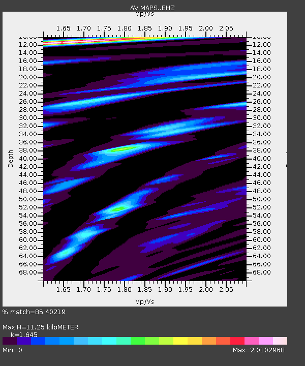
| Estimated Moho Depth: |
11.25 km |
| Estimated Crust Vp/Vs: |
1.64 |
| Assumed Crust Vp: |
3.943 km/s |
| Estimated Crust Vs: |
2.397 km/s |
| Estimated Crust Poisson's Ratio: |
0.21 |
|
| Radial Match: |
85.40219 % |
| Radial Bump: |
400 |
| Transverse Match: |
80.34475 % |
| Transverse Bump: |
400 |
| SOD ConfigId: |
18369291 |
| Insert Time: |
2019-06-29 22:56:20.343 +0000 |
| GWidth: |
2.5 |
| Max Bumps: |
400 |
| Tol: |
0.001 |
|

Signal To Noise
| Channel | StoN | STA | LTA |
| AV:MAPS: :BHZ:20190615T23:06:58.898987Z | 14.3799 | 4.136613E-6 | 2.8766632E-7 |
| AV:MAPS: :BHN:20190615T23:06:58.898987Z | 1.5925409 | 8.9340483E-7 | 5.609933E-7 |
| AV:MAPS: :BHE:20190615T23:06:58.898987Z | 2.0640438 | 9.962391E-7 | 4.826638E-7 |
| Arrivals |
| Ps | 1.9 SECOND |
| PpPs | 7.5 SECOND |
| PsPs/PpSs | 9.3 SECOND |


