You are here: Home > Network List > GS - US Geological Survey Networks Stations List
> Station OK025 Westminster Rd and Hefner Rd, NE Oklahoma City, Oklahoma, U. > Earthquake Result Viewer
OK025 Westminster Rd and Hefner Rd, NE Oklahoma City, Oklahoma, U. - Earthquake Result Viewer

| Earthquake location: |
San Juan Province, Argentina |
| Earthquake latitude/longitude: |
-31.6/-68.8 |
| Earthquake time(UTC): |
2016/11/20 (325) 20:57:43 GMT |
| Earthquake Depth: |
116 km |
| Earthquake Magnitude: |
6.4 MWP, 6.5 MWB |
| Earthquake Catalog/Contributor: |
NEIC PDE/NEIC COMCAT |
|
| Network: |
GS US Geological Survey Networks |
| Station: |
OK025 Westminster Rd and Hefner Rd, NE Oklahoma City, Oklahoma, U. |
| Lat/Lon: |
35.58 N/97.34 W |
| Elevation: |
348 m |
|
| Distance: |
72.1 deg |
| Az: |
335.807 deg |
| Baz: |
154.609 deg |
| Ray Param: |
0.053625867 |
| Estimated Moho Depth: |
67.5 km |
| Estimated Crust Vp/Vs: |
2.03 |
| Assumed Crust Vp: |
6.426 km/s |
| Estimated Crust Vs: |
3.169 km/s |
| Estimated Crust Poisson's Ratio: |
0.34 |
|
| Radial Match: |
87.12935 % |
| Radial Bump: |
400 |
| Transverse Match: |
78.84633 % |
| Transverse Bump: |
400 |
| SOD ConfigId: |
1858631 |
| Insert Time: |
2016-12-04 21:00:55.559 +0000 |
| GWidth: |
2.5 |
| Max Bumps: |
400 |
| Tol: |
0.001 |
|
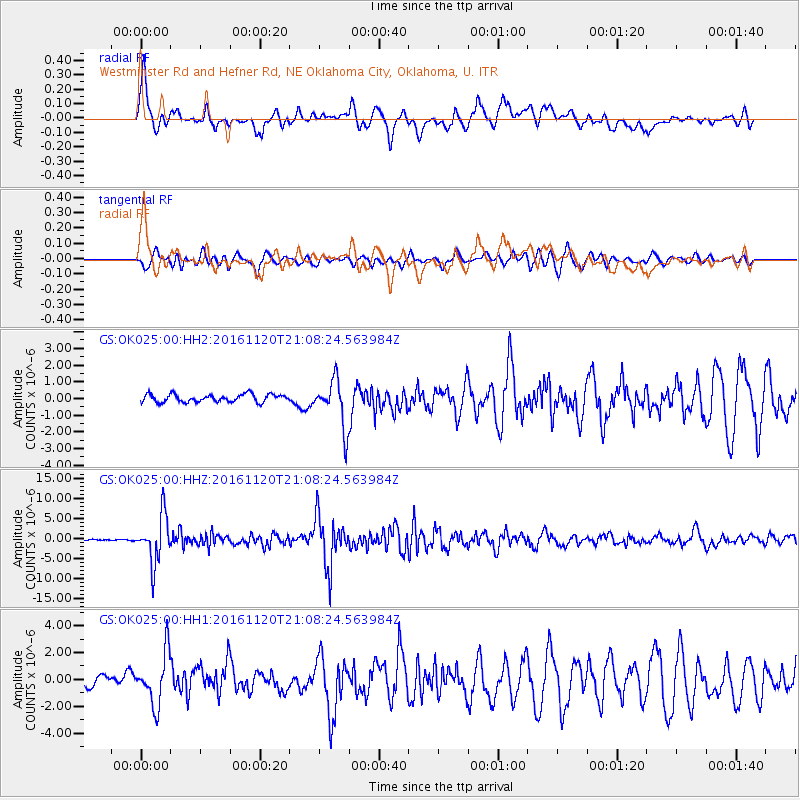
Signal To Noise
| Channel | StoN | STA | LTA |
| GS:OK025:00:HHZ:20161120T21:08:24.563984Z | 31.919983 | 5.8938685E-6 | 1.846451E-7 |
| GS:OK025:00:HH1:20161120T21:08:24.563984Z | 4.87691 | 1.8965582E-6 | 3.8888518E-7 |
| GS:OK025:00:HH2:20161120T21:08:24.563984Z | 6.107656 | 1.4260478E-6 | 2.3348528E-7 |
| Arrivals |
| Ps | 11 SECOND |
| PpPs | 31 SECOND |
| PsPs/PpSs | 42 SECOND |


