You are here: Home > Network List > TA - USArray Transportable Network (new EarthScope stations) Stations List
> Station J19K Poorman, AK, USA > Earthquake Result Viewer
J19K Poorman, AK, USA - Earthquake Result Viewer
| Earthquake location: |
Kermadec Islands Region |
| Earthquake latitude/longitude: |
-31.0/-177.4 |
| Earthquake time(UTC): |
2019/06/15 (166) 22:54:55 GMT |
| Earthquake Depth: |
10 km |
| Earthquake Magnitude: |
7.4 Mi |
| Earthquake Catalog/Contributor: |
NEIC PDE/pt |
|
| Network: |
TA USArray Transportable Network (new EarthScope stations) |
| Station: |
J19K Poorman, AK, USA |
| Lat/Lon: |
63.99 N/155.62 W |
| Elevation: |
389 m |
|
| Distance: |
96.3 deg |
| Az: |
9.476 deg |
| Baz: |
198.697 deg |
| Ray Param: |
0.040562768 |
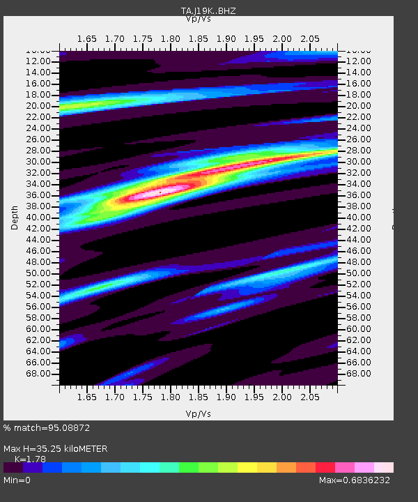
| Estimated Moho Depth: |
35.25 km |
| Estimated Crust Vp/Vs: |
1.78 |
| Assumed Crust Vp: |
6.438 km/s |
| Estimated Crust Vs: |
3.617 km/s |
| Estimated Crust Poisson's Ratio: |
0.27 |
|
| Radial Match: |
95.08872 % |
| Radial Bump: |
400 |
| Transverse Match: |
73.981865 % |
| Transverse Bump: |
400 |
| SOD ConfigId: |
18369291 |
| Insert Time: |
2019-06-29 22:59:36.655 +0000 |
| GWidth: |
2.5 |
| Max Bumps: |
400 |
| Tol: |
0.001 |
|

Signal To Noise
| Channel | StoN | STA | LTA |
| TA:J19K: :BHZ:20190615T23:07:51.724976Z | 4.099515 | 7.097726E-7 | 1.7313577E-7 |
| TA:J19K: :BHN:20190615T23:07:51.724976Z | 0.9914847 | 2.0080671E-7 | 2.0253133E-7 |
| TA:J19K: :BHE:20190615T23:07:51.724976Z | 1.6511583 | 1.4950858E-7 | 9.0547694E-8 |
| Arrivals |
| Ps | 4.4 SECOND |
| PpPs | 15 SECOND |
| PsPs/PpSs | 19 SECOND |


