You are here: Home > Network List > GS - US Geological Survey Networks Stations List
> Station OK045 Pawnee, OK, Station 45 > Earthquake Result Viewer
OK045 Pawnee, OK, Station 45 - Earthquake Result Viewer
| Earthquake location: |
San Juan Province, Argentina |
| Earthquake latitude/longitude: |
-31.6/-68.8 |
| Earthquake time(UTC): |
2016/11/20 (325) 20:57:43 GMT |
| Earthquake Depth: |
116 km |
| Earthquake Magnitude: |
6.4 MWP, 6.5 MWB |
| Earthquake Catalog/Contributor: |
NEIC PDE/NEIC COMCAT |
|
| Network: |
GS US Geological Survey Networks |
| Station: |
OK045 Pawnee, OK, Station 45 |
| Lat/Lon: |
36.45 N/96.92 W |
| Elevation: |
284 m |
|
| Distance: |
72.7 deg |
| Az: |
336.511 deg |
| Baz: |
155.064 deg |
| Ray Param: |
0.05320897 |
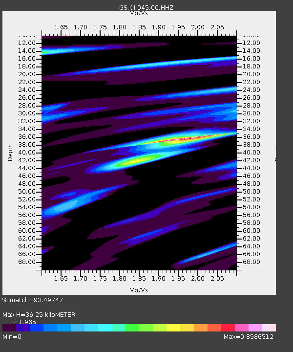
| Estimated Moho Depth: |
36.25 km |
| Estimated Crust Vp/Vs: |
1.97 |
| Assumed Crust Vp: |
6.483 km/s |
| Estimated Crust Vs: |
3.299 km/s |
| Estimated Crust Poisson's Ratio: |
0.33 |
|
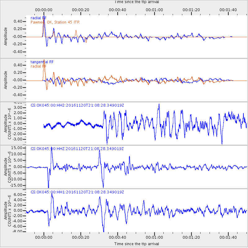
| Radial Match: |
93.49747 % |
| Radial Bump: |
400 |
| Transverse Match: |
75.695305 % |
| Transverse Bump: |
400 |
| SOD ConfigId: |
1858631 |
| Insert Time: |
2016-12-04 21:01:12.619 +0000 |
| GWidth: |
2.5 |
| Max Bumps: |
400 |
| Tol: |
0.001 |
|
Signal To Noise
| Channel | StoN | STA | LTA |
| GS:OK045:00:HHZ:20161120T21:08:28.349019Z | 29.788013 | 6.8992567E-6 | 2.3161185E-7 |
| GS:OK045:00:HH1:20161120T21:08:28.349019Z | 7.5448365 | 2.9515877E-6 | 3.9120633E-7 |
| GS:OK045:00:HH2:20161120T21:08:28.349019Z | 4.3659706 | 1.4989306E-6 | 3.433213E-7 |
| Arrivals |
| Ps | 5.6 SECOND |
| PpPs | 16 SECOND |
| PsPs/PpSs | 22 SECOND |


