You are here: Home > Network List > TA - USArray Transportable Network (new EarthScope stations) Stations List
> Station L18K Granite Mountain, AK, USA > Earthquake Result Viewer
L18K Granite Mountain, AK, USA - Earthquake Result Viewer
| Earthquake location: |
Kermadec Islands Region |
| Earthquake latitude/longitude: |
-31.0/-177.4 |
| Earthquake time(UTC): |
2019/06/15 (166) 22:54:55 GMT |
| Earthquake Depth: |
10 km |
| Earthquake Magnitude: |
7.4 Mi |
| Earthquake Catalog/Contributor: |
NEIC PDE/pt |
|
| Network: |
TA USArray Transportable Network (new EarthScope stations) |
| Station: |
L18K Granite Mountain, AK, USA |
| Lat/Lon: |
62.22 N/156.69 W |
| Elevation: |
329 m |
|
| Distance: |
94.4 deg |
| Az: |
9.573 deg |
| Baz: |
197.738 deg |
| Ray Param: |
0.0410475 |
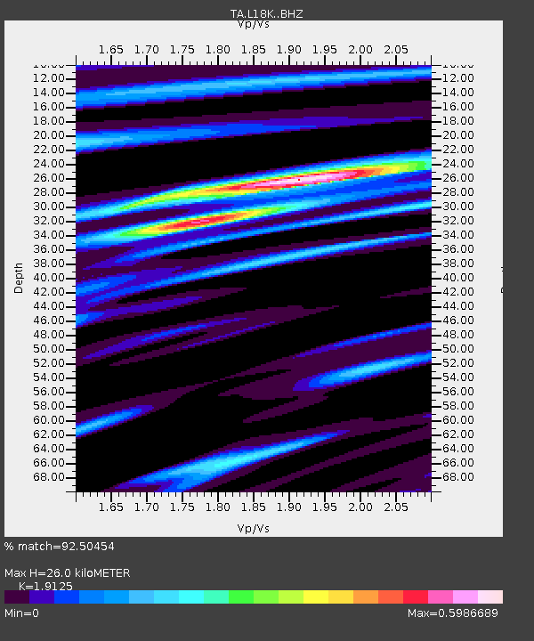
| Estimated Moho Depth: |
26.0 km |
| Estimated Crust Vp/Vs: |
1.91 |
| Assumed Crust Vp: |
6.182 km/s |
| Estimated Crust Vs: |
3.233 km/s |
| Estimated Crust Poisson's Ratio: |
0.31 |
|
| Radial Match: |
92.50454 % |
| Radial Bump: |
400 |
| Transverse Match: |
65.957664 % |
| Transverse Bump: |
400 |
| SOD ConfigId: |
18369291 |
| Insert Time: |
2019-06-29 22:59:43.518 +0000 |
| GWidth: |
2.5 |
| Max Bumps: |
400 |
| Tol: |
0.001 |
|

Signal To Noise
| Channel | StoN | STA | LTA |
| TA:L18K: :BHZ:20190615T23:07:43.375Z | 2.6395926 | 5.8495283E-7 | 2.2160724E-7 |
| TA:L18K: :BHN:20190615T23:07:43.375Z | 0.92716557 | 2.0626192E-7 | 2.2246502E-7 |
| TA:L18K: :BHE:20190615T23:07:43.375Z | 1.3438654 | 2.3702357E-7 | 1.7637448E-7 |
| Arrivals |
| Ps | 3.9 SECOND |
| PpPs | 12 SECOND |
| PsPs/PpSs | 16 SECOND |


