You are here: Home > Network List > TA - USArray Transportable Network (new EarthScope stations) Stations List
> Station L20K Farewell, AK, USA > Earthquake Result Viewer
L20K Farewell, AK, USA - Earthquake Result Viewer
| Earthquake location: |
Kermadec Islands Region |
| Earthquake latitude/longitude: |
-31.0/-177.4 |
| Earthquake time(UTC): |
2019/06/15 (166) 22:54:55 GMT |
| Earthquake Depth: |
10 km |
| Earthquake Magnitude: |
7.4 Mi |
| Earthquake Catalog/Contributor: |
NEIC PDE/pt |
|
| Network: |
TA USArray Transportable Network (new EarthScope stations) |
| Station: |
L20K Farewell, AK, USA |
| Lat/Lon: |
62.48 N/153.88 W |
| Elevation: |
673 m |
|
| Distance: |
95.1 deg |
| Az: |
10.732 deg |
| Baz: |
200.126 deg |
| Ray Param: |
0.0408742 |
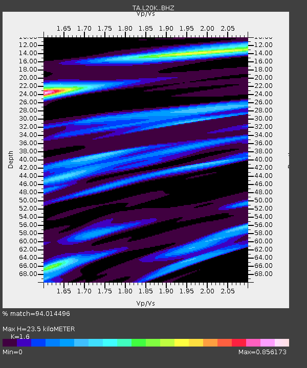
| Estimated Moho Depth: |
23.5 km |
| Estimated Crust Vp/Vs: |
1.60 |
| Assumed Crust Vp: |
6.566 km/s |
| Estimated Crust Vs: |
4.104 km/s |
| Estimated Crust Poisson's Ratio: |
0.18 |
|
| Radial Match: |
94.014496 % |
| Radial Bump: |
400 |
| Transverse Match: |
82.87699 % |
| Transverse Bump: |
400 |
| SOD ConfigId: |
18369291 |
| Insert Time: |
2019-06-29 22:59:44.010 +0000 |
| GWidth: |
2.5 |
| Max Bumps: |
400 |
| Tol: |
0.001 |
|
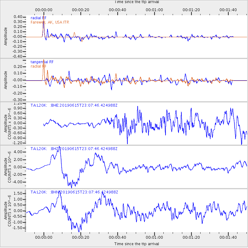
Signal To Noise
| Channel | StoN | STA | LTA |
| TA:L20K: :BHZ:20190615T23:07:46.424988Z | 5.5248694 | 1.5249702E-6 | 2.7601922E-7 |
| TA:L20K: :BHN:20190615T23:07:46.424988Z | 2.8647633 | 3.6544967E-7 | 1.2756715E-7 |
| TA:L20K: :BHE:20190615T23:07:46.424988Z | 1.7465209 | 1.7593786E-7 | 1.0073619E-7 |
| Arrivals |
| Ps | 2.2 SECOND |
| PpPs | 9.1 SECOND |
| PsPs/PpSs | 11 SECOND |


