You are here: Home > Network List > TA - USArray Transportable Network (new EarthScope stations) Stations List
> Station P19K Oil Pt, AK, USA > Earthquake Result Viewer
P19K Oil Pt, AK, USA - Earthquake Result Viewer
| Earthquake location: |
Kermadec Islands Region |
| Earthquake latitude/longitude: |
-31.0/-177.4 |
| Earthquake time(UTC): |
2019/06/15 (166) 22:54:55 GMT |
| Earthquake Depth: |
10 km |
| Earthquake Magnitude: |
7.4 Mi |
| Earthquake Catalog/Contributor: |
NEIC PDE/pt |
|
| Network: |
TA USArray Transportable Network (new EarthScope stations) |
| Station: |
P19K Oil Pt, AK, USA |
| Lat/Lon: |
59.65 N/153.23 W |
| Elevation: |
629 m |
|
| Distance: |
92.5 deg |
| Az: |
12.017 deg |
| Baz: |
200.607 deg |
| Ray Param: |
0.041437786 |
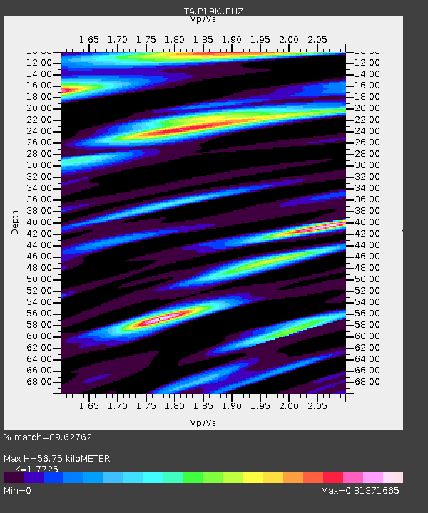
| Estimated Moho Depth: |
56.75 km |
| Estimated Crust Vp/Vs: |
1.77 |
| Assumed Crust Vp: |
5.989 km/s |
| Estimated Crust Vs: |
3.379 km/s |
| Estimated Crust Poisson's Ratio: |
0.27 |
|
| Radial Match: |
89.62762 % |
| Radial Bump: |
400 |
| Transverse Match: |
82.24943 % |
| Transverse Bump: |
400 |
| SOD ConfigId: |
18369291 |
| Insert Time: |
2019-06-29 23:00:01.556 +0000 |
| GWidth: |
2.5 |
| Max Bumps: |
400 |
| Tol: |
0.001 |
|

Signal To Noise
| Channel | StoN | STA | LTA |
| TA:P19K: :BHZ:20190615T23:07:34.775024Z | 6.2137117 | 2.148758E-6 | 3.4580907E-7 |
| TA:P19K: :BHN:20190615T23:07:34.775024Z | 1.8175162 | 5.5581853E-7 | 3.0581216E-7 |
| TA:P19K: :BHE:20190615T23:07:34.775024Z | 1.757473 | 5.843085E-7 | 3.3247085E-7 |
| Arrivals |
| Ps | 7.5 SECOND |
| PpPs | 26 SECOND |
| PsPs/PpSs | 33 SECOND |


