You are here: Home > Network List > IU - Global Seismograph Network (GSN - IRIS/USGS) Stations List
> Station PAYG Puerto Ayora, Galapagos Islands > Earthquake Result Viewer
PAYG Puerto Ayora, Galapagos Islands - Earthquake Result Viewer
| Earthquake location: |
San Juan Province, Argentina |
| Earthquake latitude/longitude: |
-31.6/-68.8 |
| Earthquake time(UTC): |
2016/11/20 (325) 20:57:43 GMT |
| Earthquake Depth: |
116 km |
| Earthquake Magnitude: |
6.4 MWP, 6.5 MWB |
| Earthquake Catalog/Contributor: |
NEIC PDE/NEIC COMCAT |
|
| Network: |
IU Global Seismograph Network (GSN - IRIS/USGS) |
| Station: |
PAYG Puerto Ayora, Galapagos Islands |
| Lat/Lon: |
0.67 S/90.29 W |
| Elevation: |
270 m |
|
| Distance: |
36.9 deg |
| Az: |
322.361 deg |
| Baz: |
148.608 deg |
| Ray Param: |
0.07603563 |
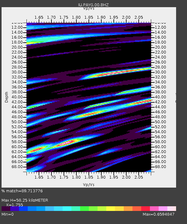
| Estimated Moho Depth: |
58.25 km |
| Estimated Crust Vp/Vs: |
1.75 |
| Assumed Crust Vp: |
4.802 km/s |
| Estimated Crust Vs: |
2.736 km/s |
| Estimated Crust Poisson's Ratio: |
0.26 |
|
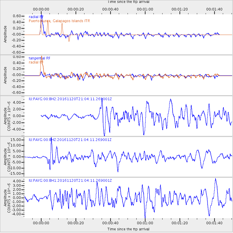
| Radial Match: |
89.713776 % |
| Radial Bump: |
400 |
| Transverse Match: |
73.94227 % |
| Transverse Bump: |
400 |
| SOD ConfigId: |
1858631 |
| Insert Time: |
2016-12-04 21:01:57.245 +0000 |
| GWidth: |
2.5 |
| Max Bumps: |
400 |
| Tol: |
0.001 |
|
Signal To Noise
| Channel | StoN | STA | LTA |
| IU:PAYG:00:BHZ:20161120T21:04:11.269001Z | 7.8526115 | 2.0349892E-6 | 2.5914807E-7 |
| IU:PAYG:00:BH1:20161120T21:04:11.269001Z | 1.0727346 | 4.1618003E-7 | 3.879618E-7 |
| IU:PAYG:00:BH2:20161120T21:04:11.269001Z | 3.1349893 | 1.2564735E-6 | 4.0079038E-7 |
| Arrivals |
| Ps | 9.5 SECOND |
| PpPs | 32 SECOND |
| PsPs/PpSs | 42 SECOND |


