You are here: Home > Network List > AT - Alaska Tsunami Warning Seismic System Stations List
> Station OHAK Old Harbor, Alaska > Earthquake Result Viewer
OHAK Old Harbor, Alaska - Earthquake Result Viewer
| Earthquake location: |
Kermadec Islands, New Zealand |
| Earthquake latitude/longitude: |
-30.8/-178.1 |
| Earthquake time(UTC): |
2019/06/15 (166) 22:55:02 GMT |
| Earthquake Depth: |
35 km |
| Earthquake Magnitude: |
7.4 Mwp |
| Earthquake Catalog/Contributor: |
NEIC PDE/us |
|
| Network: |
AT Alaska Tsunami Warning Seismic System |
| Station: |
OHAK Old Harbor, Alaska |
| Lat/Lon: |
57.22 N/153.29 W |
| Elevation: |
78 m |
|
| Distance: |
90.2 deg |
| Az: |
13.183 deg |
| Baz: |
201.144 deg |
| Ray Param: |
0.041688412 |
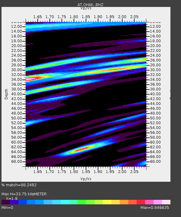
| Estimated Moho Depth: |
33.75 km |
| Estimated Crust Vp/Vs: |
1.60 |
| Assumed Crust Vp: |
6.134 km/s |
| Estimated Crust Vs: |
3.834 km/s |
| Estimated Crust Poisson's Ratio: |
0.18 |
|
| Radial Match: |
88.2492 % |
| Radial Bump: |
400 |
| Transverse Match: |
79.467514 % |
| Transverse Bump: |
400 |
| SOD ConfigId: |
18369291 |
| Insert Time: |
2019-06-29 23:02:19.939 +0000 |
| GWidth: |
2.5 |
| Max Bumps: |
400 |
| Tol: |
0.001 |
|

Signal To Noise
| Channel | StoN | STA | LTA |
| AT:OHAK: :BHZ:20190615T23:07:27.659996Z | 21.903366 | 4.470185E-6 | 2.0408669E-7 |
| AT:OHAK: :BHN:20190615T23:07:27.659996Z | 4.1683 | 1.4246116E-6 | 3.4177276E-7 |
| AT:OHAK: :BHE:20190615T23:07:27.659996Z | 1.6834947 | 4.97579E-7 | 2.9556315E-7 |
| Arrivals |
| Ps | 3.4 SECOND |
| PpPs | 14 SECOND |
| PsPs/PpSs | 17 SECOND |


