You are here: Home > Network List > TA - USArray Transportable Network (new EarthScope stations) Stations List
> Station D21A La Casta Ranch, Jordon, MT, USA > Earthquake Result Viewer
D21A La Casta Ranch, Jordon, MT, USA - Earthquake Result Viewer

| Earthquake location: |
Off Coast Of Costa Rica |
| Earthquake latitude/longitude: |
7.9/-85.6 |
| Earthquake time(UTC): |
2009/08/13 (225) 09:37:35 GMT |
| Earthquake Depth: |
10 km |
| Earthquake Magnitude: |
5.8 MW, 5.3 MB |
| Earthquake Catalog/Contributor: |
WHDF/NEIC |
|
| Network: |
TA USArray Transportable Network (new EarthScope stations) |
| Station: |
D21A La Casta Ranch, Jordon, MT, USA |
| Lat/Lon: |
47.07 N/106.99 W |
| Elevation: |
934 m |
|
| Distance: |
43.0 deg |
| Az: |
338.603 deg |
| Baz: |
148.088 deg |
| Ray Param: |
0.07280691 |
| Estimated Moho Depth: |
36.0 km |
| Estimated Crust Vp/Vs: |
2.10 |
| Assumed Crust Vp: |
6.438 km/s |
| Estimated Crust Vs: |
3.069 km/s |
| Estimated Crust Poisson's Ratio: |
0.35 |
|
| Radial Match: |
88.62964 % |
| Radial Bump: |
354 |
| Transverse Match: |
67.97004 % |
| Transverse Bump: |
400 |
| SOD ConfigId: |
2622 |
| Insert Time: |
2010-03-06 23:43:28.495 +0000 |
| GWidth: |
2.5 |
| Max Bumps: |
400 |
| Tol: |
0.001 |
|
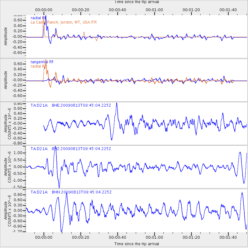
Signal To Noise
| Channel | StoN | STA | LTA |
| TA:D21A: :BHZ:20090813T09:45:04.225Z | 4.785429 | 3.3472642E-7 | 6.9947006E-8 |
| TA:D21A: :BHN:20090813T09:45:04.225Z | 1.8742226 | 1.8345416E-7 | 9.78828E-8 |
| TA:D21A: :BHE:20090813T09:45:04.225Z | 1.4175279 | 1.6887978E-7 | 1.19136836E-7 |
| Arrivals |
| Ps | 6.5 SECOND |
| PpPs | 16 SECOND |
| PsPs/PpSs | 23 SECOND |


