You are here: Home > Network List > IU - Global Seismograph Network (GSN - IRIS/USGS) Stations List
> Station TEIG Tepich, Yucatan, Mexico > Earthquake Result Viewer
TEIG Tepich, Yucatan, Mexico - Earthquake Result Viewer
| Earthquake location: |
San Juan Province, Argentina |
| Earthquake latitude/longitude: |
-31.6/-68.8 |
| Earthquake time(UTC): |
2016/11/20 (325) 20:57:43 GMT |
| Earthquake Depth: |
116 km |
| Earthquake Magnitude: |
6.4 MWP, 6.5 MWB |
| Earthquake Catalog/Contributor: |
NEIC PDE/NEIC COMCAT |
|
| Network: |
IU Global Seismograph Network (GSN - IRIS/USGS) |
| Station: |
TEIG Tepich, Yucatan, Mexico |
| Lat/Lon: |
20.23 N/88.28 W |
| Elevation: |
40 m |
|
| Distance: |
54.9 deg |
| Az: |
337.447 deg |
| Baz: |
159.614 deg |
| Ray Param: |
0.06480462 |
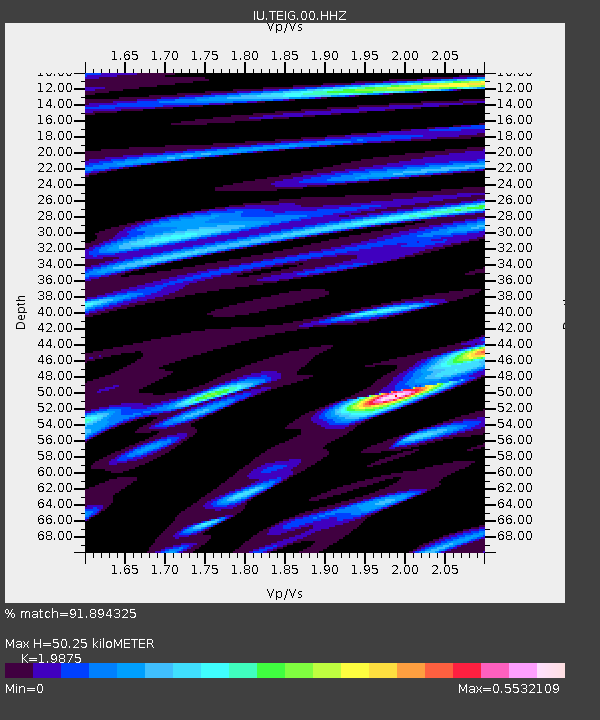
| Estimated Moho Depth: |
50.25 km |
| Estimated Crust Vp/Vs: |
1.99 |
| Assumed Crust Vp: |
5.817 km/s |
| Estimated Crust Vs: |
2.927 km/s |
| Estimated Crust Poisson's Ratio: |
0.33 |
|
| Radial Match: |
91.894325 % |
| Radial Bump: |
400 |
| Transverse Match: |
85.35525 % |
| Transverse Bump: |
400 |
| SOD ConfigId: |
1858631 |
| Insert Time: |
2016-12-04 21:02:18.537 +0000 |
| GWidth: |
2.5 |
| Max Bumps: |
400 |
| Tol: |
0.001 |
|
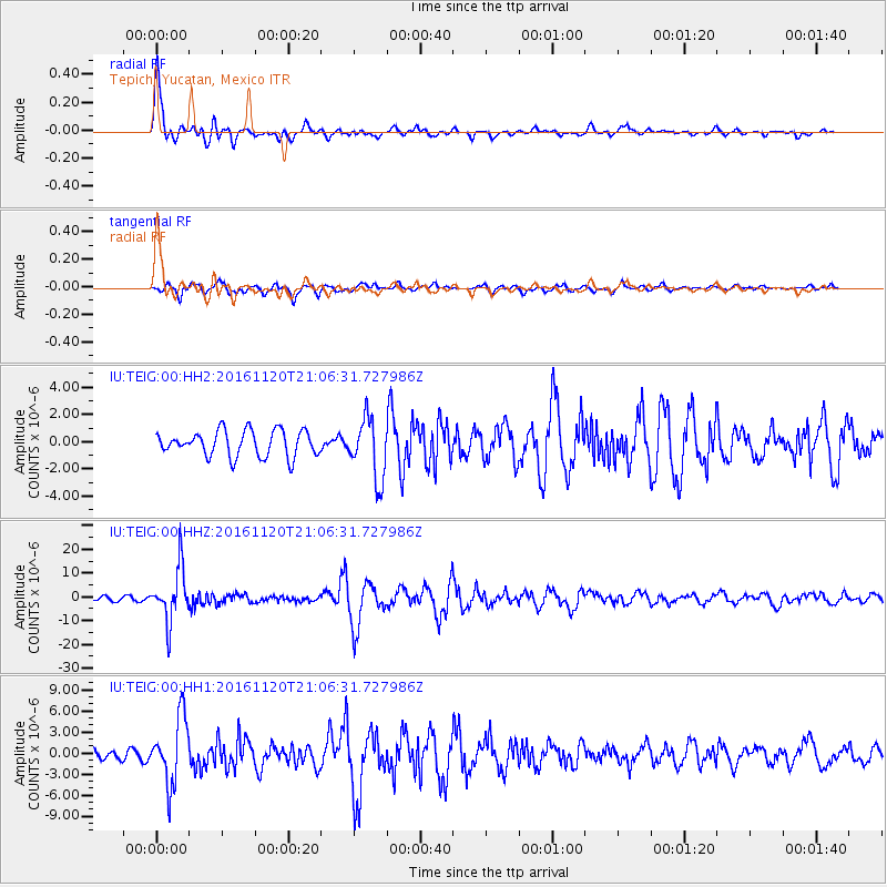
Signal To Noise
| Channel | StoN | STA | LTA |
| IU:TEIG:00:HHZ:20161120T21:06:31.727986Z | 12.9224415 | 1.1044457E-5 | 8.5467263E-7 |
| IU:TEIG:00:HH1:20161120T21:06:31.727986Z | 6.924114 | 4.7091107E-6 | 6.8010297E-7 |
| IU:TEIG:00:HH2:20161120T21:06:31.727986Z | 2.3297422 | 2.202158E-6 | 9.452367E-7 |
| Arrivals |
| Ps | 8.9 SECOND |
| PpPs | 25 SECOND |
| PsPs/PpSs | 34 SECOND |


