You are here: Home > Network List > TS - TERRAscope (Southern California Seismic Network) Stations List
> Station GSC Goldston, California, USA > Earthquake Result Viewer
GSC Goldston, California, USA - Earthquake Result Viewer
| Earthquake location: |
Northern Colombia |
| Earthquake latitude/longitude: |
7.1/-76.9 |
| Earthquake time(UTC): |
1992/10/18 (292) 15:11:59 GMT |
| Earthquake Depth: |
10 km |
| Earthquake Magnitude: |
6.6 MB, 7.3 MS, 7.4 UNKNOWN |
| Earthquake Catalog/Contributor: |
WHDF/NEIC |
|
| Network: |
TS TERRAscope (Southern California Seismic Network) |
| Station: |
GSC Goldston, California, USA |
| Lat/Lon: |
35.30 N/116.81 W |
| Elevation: |
990 m |
|
| Distance: |
46.1 deg |
| Az: |
313.243 deg |
| Baz: |
117.894 deg |
| Ray Param: |
0.07085292 |
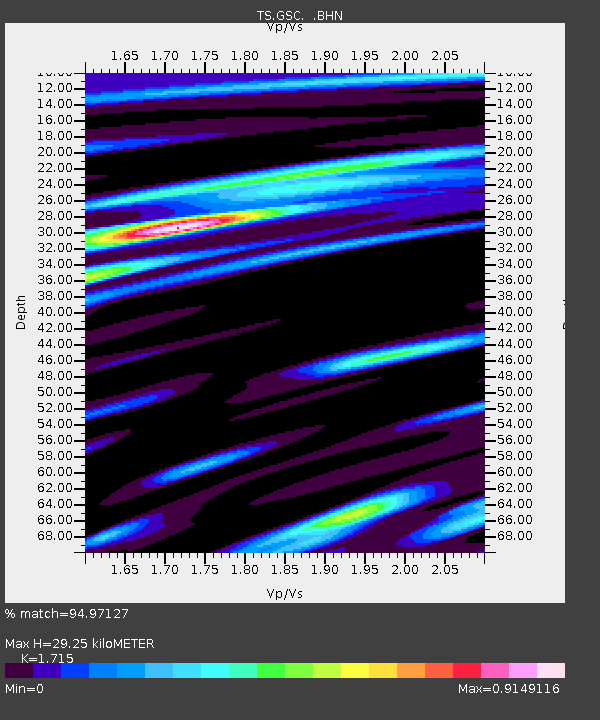
| Estimated Moho Depth: |
29.25 km |
| Estimated Crust Vp/Vs: |
1.72 |
| Assumed Crust Vp: |
6.276 km/s |
| Estimated Crust Vs: |
3.659 km/s |
| Estimated Crust Poisson's Ratio: |
0.24 |
|
| Radial Match: |
94.97127 % |
| Radial Bump: |
371 |
| Transverse Match: |
79.04175 % |
| Transverse Bump: |
400 |
| SOD ConfigId: |
16938 |
| Insert Time: |
2010-02-26 14:15:46.393 +0000 |
| GWidth: |
2.5 |
| Max Bumps: |
400 |
| Tol: |
0.001 |
|

Signal To Noise
| Channel | StoN | STA | LTA |
| TS:GSC: :BHN:19921018T15:19:52.608014Z | 0.94479513 | 1.5193206E-7 | 1.6080953E-7 |
| TS:GSC: :BHE:19921018T15:19:52.608014Z | 3.9343665 | 3.521568E-7 | 8.950788E-8 |
| TS:GSC: :BHZ:19921018T15:19:52.608014Z | 2.6740088 | 4.1917528E-7 | 1.5675913E-7 |
| Arrivals |
| Ps | 3.5 SECOND |
| PpPs | 12 SECOND |
| PsPs/PpSs | 15 SECOND |


