You are here: Home > Network List > C1 - Red Sismologica Nacional Stations List
> Station MT10 Hacienda Santa Martina > Earthquake Result Viewer
MT10 Hacienda Santa Martina - Earthquake Result Viewer
| Earthquake location: |
Kermadec Islands, New Zealand |
| Earthquake latitude/longitude: |
-30.8/-178.1 |
| Earthquake time(UTC): |
2019/06/15 (166) 22:55:02 GMT |
| Earthquake Depth: |
35 km |
| Earthquake Magnitude: |
7.4 Mwp |
| Earthquake Catalog/Contributor: |
NEIC PDE/us |
|
| Network: |
C1 Red Sismologica Nacional |
| Station: |
MT10 Hacienda Santa Martina |
| Lat/Lon: |
33.27 S/70.54 W |
| Elevation: |
1410 m |
|
| Distance: |
86.5 deg |
| Az: |
126.841 deg |
| Baz: |
235.271 deg |
| Ray Param: |
0.043965142 |
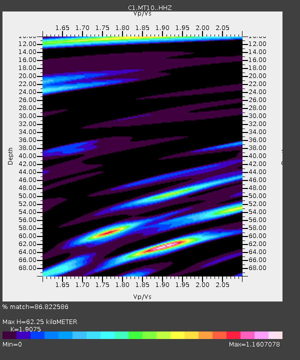
| Estimated Moho Depth: |
62.25 km |
| Estimated Crust Vp/Vs: |
1.91 |
| Assumed Crust Vp: |
6.481 km/s |
| Estimated Crust Vs: |
3.398 km/s |
| Estimated Crust Poisson's Ratio: |
0.31 |
|
| Radial Match: |
86.822586 % |
| Radial Bump: |
400 |
| Transverse Match: |
81.927826 % |
| Transverse Bump: |
400 |
| SOD ConfigId: |
18369291 |
| Insert Time: |
2019-06-29 23:04:03.603 +0000 |
| GWidth: |
2.5 |
| Max Bumps: |
400 |
| Tol: |
0.001 |
|

Signal To Noise
| Channel | StoN | STA | LTA |
| C1:MT10: :HHZ:20190615T23:07:10.268028Z | 6.9605126 | 4.2861857E-6 | 6.157859E-7 |
| C1:MT10: :HHN:20190615T23:07:10.268028Z | 2.0384135 | 9.099123E-7 | 4.4638256E-7 |
| C1:MT10: :HHE:20190615T23:07:10.268028Z | 3.1479082 | 1.9597067E-6 | 6.2254253E-7 |
| Arrivals |
| Ps | 8.9 SECOND |
| PpPs | 27 SECOND |
| PsPs/PpSs | 36 SECOND |


