You are here: Home > Network List > TA - USArray Transportable Network (new EarthScope stations) Stations List
> Station D21A La Casta Ranch, Jordon, MT, USA > Earthquake Result Viewer
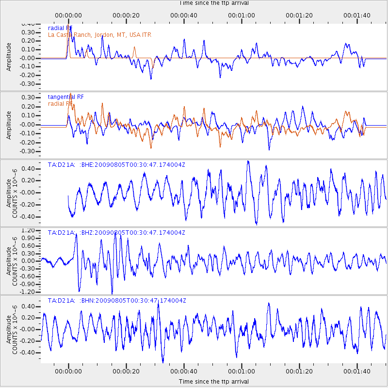
D21A La Casta Ranch, Jordon, MT, USA - Earthquake Result Viewer
*The percent match for this event was below the threshold and hence no stack was calculated.
| Earthquake location: |
Southwestern Ryukyu Isl., Japan |
| Earthquake latitude/longitude: |
24.2/125.1 |
| Earthquake time(UTC): |
2009/08/05 (217) 00:17:58 GMT |
| Earthquake Depth: |
25 km |
| Earthquake Magnitude: |
5.9 MB, 5.9 MS, 6.2 MW, 6.1 MW |
| Earthquake Catalog/Contributor: |
WHDF/NEIC |
|
| Network: |
TA USArray Transportable Network (new EarthScope stations) |
| Station: |
D21A La Casta Ranch, Jordon, MT, USA |
| Lat/Lon: |
47.07 N/106.99 W |
| Elevation: |
934 m |
|
| Distance: |
94.9 deg |
| Az: |
32.774 deg |
| Baz: |
313.705 deg |
| Ray Param: |
$rayparam |
*The percent match for this event was below the threshold and hence was not used in the summary stack. |
|
| Radial Match: |
73.109856 % |
| Radial Bump: |
400 |
| Transverse Match: |
64.44951 % |
| Transverse Bump: |
400 |
| SOD ConfigId: |
2622 |
| Insert Time: |
2010-03-06 23:44:28.032 +0000 |
| GWidth: |
2.5 |
| Max Bumps: |
400 |
| Tol: |
0.001 |
|
Signal To Noise
| Channel | StoN | STA | LTA |
| TA:D21A: :BHZ:20090805T00:30:47.174004Z | 5.9045515 | 5.559631E-7 | 9.415839E-8 |
| TA:D21A: :BHN:20090805T00:30:47.174004Z | 0.8868283 | 1.5376298E-7 | 1.733853E-7 |
| TA:D21A: :BHE:20090805T00:30:47.174004Z | 1.2150724 | 1.8455067E-7 | 1.518845E-7 |
| Arrivals |
| Ps | |
| PpPs | |
| PsPs/PpSs | |


