You are here: Home > Network List > IW - Intermountain West Stations List
> Station MOOW Moose Ponds, Wyoming, USA > Earthquake Result Viewer
MOOW Moose Ponds, Wyoming, USA - Earthquake Result Viewer
| Earthquake location: |
San Juan Province, Argentina |
| Earthquake latitude/longitude: |
-31.6/-68.8 |
| Earthquake time(UTC): |
2016/11/20 (325) 20:57:43 GMT |
| Earthquake Depth: |
116 km |
| Earthquake Magnitude: |
6.4 MWP, 6.5 MWB |
| Earthquake Catalog/Contributor: |
NEIC PDE/NEIC COMCAT |
|
| Network: |
IW Intermountain West |
| Station: |
MOOW Moose Ponds, Wyoming, USA |
| Lat/Lon: |
43.75 N/110.74 W |
| Elevation: |
2128 m |
|
| Distance: |
84.3 deg |
| Az: |
330.846 deg |
| Baz: |
145.016 deg |
| Ray Param: |
0.045341708 |
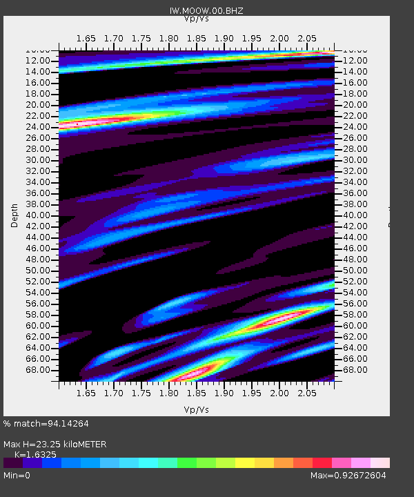
| Estimated Moho Depth: |
23.25 km |
| Estimated Crust Vp/Vs: |
1.63 |
| Assumed Crust Vp: |
6.207 km/s |
| Estimated Crust Vs: |
3.802 km/s |
| Estimated Crust Poisson's Ratio: |
0.20 |
|
| Radial Match: |
94.14264 % |
| Radial Bump: |
400 |
| Transverse Match: |
90.78837 % |
| Transverse Bump: |
342 |
| SOD ConfigId: |
1858631 |
| Insert Time: |
2016-12-04 21:02:37.332 +0000 |
| GWidth: |
2.5 |
| Max Bumps: |
400 |
| Tol: |
0.001 |
|

Signal To Noise
| Channel | StoN | STA | LTA |
| IW:MOOW:00:BHZ:20161120T21:09:31.690022Z | 17.180185 | 2.995864E-6 | 1.7437902E-7 |
| IW:MOOW:00:BH1:20161120T21:09:31.690022Z | 5.5055575 | 8.354776E-7 | 1.5175168E-7 |
| IW:MOOW:00:BH2:20161120T21:09:31.690022Z | 3.5638084 | 6.3767095E-7 | 1.7892962E-7 |
| Arrivals |
| Ps | 2.4 SECOND |
| PpPs | 9.6 SECOND |
| PsPs/PpSs | 12 SECOND |


