You are here: Home > Network List > TA - USArray Transportable Network (new EarthScope stations) Stations List
> Station D21A La Casta Ranch, Jordon, MT, USA > Earthquake Result Viewer
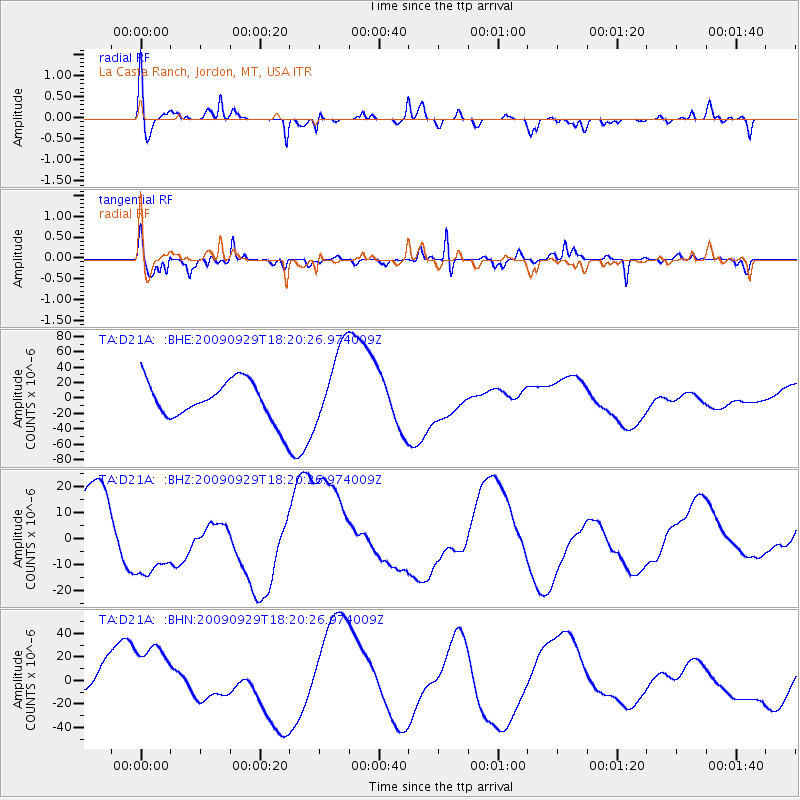
D21A La Casta Ranch, Jordon, MT, USA - Earthquake Result Viewer
*The percent match for this event was below the threshold and hence no stack was calculated.
| Earthquake location: |
Samoa Islands Region |
| Earthquake latitude/longitude: |
-15.6/-172.0 |
| Earthquake time(UTC): |
2009/09/29 (272) 18:08:21 GMT |
| Earthquake Depth: |
10 km |
| Earthquake Magnitude: |
5.6 MB |
| Earthquake Catalog/Contributor: |
WHDF/NEIC |
|
| Network: |
TA USArray Transportable Network (new EarthScope stations) |
| Station: |
D21A La Casta Ranch, Jordon, MT, USA |
| Lat/Lon: |
47.07 N/106.99 W |
| Elevation: |
934 m |
|
| Distance: |
85.2 deg |
| Az: |
38.451 deg |
| Baz: |
241.253 deg |
| Ray Param: |
$rayparam |
*The percent match for this event was below the threshold and hence was not used in the summary stack. |
|
| Radial Match: |
52.720524 % |
| Radial Bump: |
400 |
| Transverse Match: |
76.276054 % |
| Transverse Bump: |
329 |
| SOD ConfigId: |
2622 |
| Insert Time: |
2010-03-06 23:44:42.701 +0000 |
| GWidth: |
2.5 |
| Max Bumps: |
400 |
| Tol: |
0.001 |
|
Signal To Noise
| Channel | StoN | STA | LTA |
| TA:D21A: :BHZ:20090929T18:20:26.974009Z | 0.7518448 | 1.6976792E-5 | 2.258018E-5 |
| TA:D21A: :BHN:20090929T18:20:26.974009Z | 2.0148268 | 3.0168223E-5 | 1.4973111E-5 |
| TA:D21A: :BHE:20090929T18:20:26.974009Z | 2.075335 | 5.2640695E-5 | 2.5364916E-5 |
| Arrivals |
| Ps | |
| PpPs | |
| PsPs/PpSs | |


