You are here: Home > Network List > CN - Canadian National Seismograph Network Stations List
> Station CBB Campbell River, BC, CA > Earthquake Result Viewer
CBB Campbell River, BC, CA - Earthquake Result Viewer
| Earthquake location: |
Kermadec Islands, New Zealand |
| Earthquake latitude/longitude: |
-30.8/-178.1 |
| Earthquake time(UTC): |
2019/06/15 (166) 22:55:02 GMT |
| Earthquake Depth: |
35 km |
| Earthquake Magnitude: |
7.4 Mwp |
| Earthquake Catalog/Contributor: |
NEIC PDE/us |
|
| Network: |
CN Canadian National Seismograph Network |
| Station: |
CBB Campbell River, BC, CA |
| Lat/Lon: |
50.03 N/125.37 W |
| Elevation: |
277 m |
|
| Distance: |
93.1 deg |
| Az: |
30.918 deg |
| Baz: |
223.27 deg |
| Ray Param: |
0.041322548 |
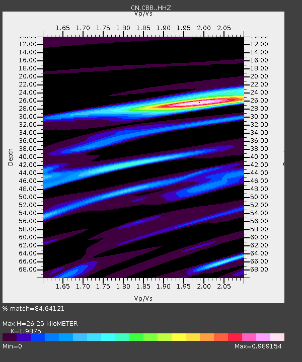
| Estimated Moho Depth: |
26.25 km |
| Estimated Crust Vp/Vs: |
1.99 |
| Assumed Crust Vp: |
6.566 km/s |
| Estimated Crust Vs: |
3.304 km/s |
| Estimated Crust Poisson's Ratio: |
0.33 |
|
| Radial Match: |
84.64121 % |
| Radial Bump: |
400 |
| Transverse Match: |
82.027016 % |
| Transverse Bump: |
400 |
| SOD ConfigId: |
18369291 |
| Insert Time: |
2019-06-29 23:05:13.981 +0000 |
| GWidth: |
2.5 |
| Max Bumps: |
400 |
| Tol: |
0.001 |
|

Signal To Noise
| Channel | StoN | STA | LTA |
| CN:CBB: :HHZ:20190615T23:07:41.029991Z | 4.6499763 | 2.294793E-6 | 4.935064E-7 |
| CN:CBB: :HHN:20190615T23:07:41.029991Z | 2.0774333 | 8.668541E-7 | 4.1727174E-7 |
| CN:CBB: :HHE:20190615T23:07:41.029991Z | 3.5469685 | 5.892478E-7 | 1.6612717E-7 |
| Arrivals |
| Ps | 4.0 SECOND |
| PpPs | 12 SECOND |
| PsPs/PpSs | 16 SECOND |


