You are here: Home > Network List > TS - TERRAscope (Southern California Seismic Network) Stations List
> Station GSC Goldston, California, USA > Earthquake Result Viewer
GSC Goldston, California, USA - Earthquake Result Viewer
| Earthquake location: |
Off Coast Of Chiapas, Mexico |
| Earthquake latitude/longitude: |
13.9/-92.3 |
| Earthquake time(UTC): |
1992/02/21 (052) 22:09:52 GMT |
| Earthquake Depth: |
37 km |
| Earthquake Magnitude: |
5.0 MB, 5.6 MS |
| Earthquake Catalog/Contributor: |
WHDF/NEIC |
|
| Network: |
TS TERRAscope (Southern California Seismic Network) |
| Station: |
GSC Goldston, California, USA |
| Lat/Lon: |
35.30 N/116.81 W |
| Elevation: |
990 m |
|
| Distance: |
30.7 deg |
| Az: |
318.284 deg |
| Baz: |
127.812 deg |
| Ray Param: |
0.07922881 |
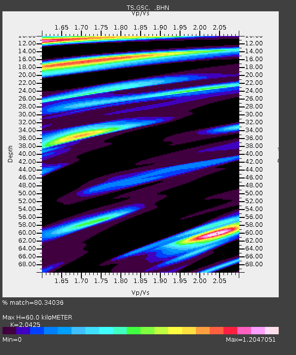
| Estimated Moho Depth: |
60.0 km |
| Estimated Crust Vp/Vs: |
2.04 |
| Assumed Crust Vp: |
6.276 km/s |
| Estimated Crust Vs: |
3.073 km/s |
| Estimated Crust Poisson's Ratio: |
0.34 |
|
| Radial Match: |
80.34036 % |
| Radial Bump: |
400 |
| Transverse Match: |
67.4468 % |
| Transverse Bump: |
400 |
| SOD ConfigId: |
17000 |
| Insert Time: |
2010-02-26 14:15:48.650 +0000 |
| GWidth: |
2.5 |
| Max Bumps: |
400 |
| Tol: |
0.001 |
|

Signal To Noise
| Channel | StoN | STA | LTA |
| TS:GSC: :BHN:19920221T22:15:33.701007Z | 0.7266902 | 1.2289989E-7 | 1.6912283E-7 |
| TS:GSC: :BHE:19920221T22:15:33.701007Z | 3.0633762 | 3.9443606E-7 | 1.2875861E-7 |
| TS:GSC: :BHZ:19920221T22:15:33.701007Z | 1.1593205 | 2.1722899E-7 | 1.8737613E-7 |
| Arrivals |
| Ps | 11 SECOND |
| PpPs | 27 SECOND |
| PsPs/PpSs | 38 SECOND |


