You are here: Home > Network List > TA - USArray Transportable Network (new EarthScope stations) Stations List
> Station D21A La Casta Ranch, Jordon, MT, USA > Earthquake Result Viewer
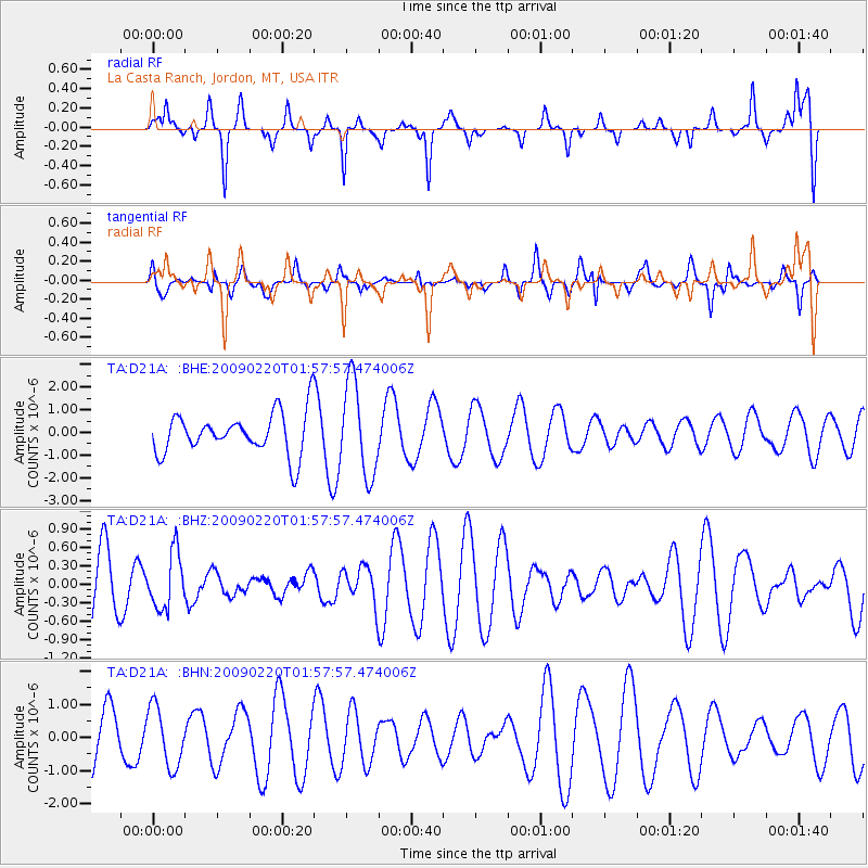
D21A La Casta Ranch, Jordon, MT, USA - Earthquake Result Viewer
*The percent match for this event was below the threshold and hence no stack was calculated.
| Earthquake location: |
Fiji Islands Region |
| Earthquake latitude/longitude: |
-18.4/-178.7 |
| Earthquake time(UTC): |
2009/02/20 (051) 01:46:17 GMT |
| Earthquake Depth: |
515 km |
| Earthquake Magnitude: |
5.6 MW, 5.1 MB, 5.6 MW |
| Earthquake Catalog/Contributor: |
WHDF/NEIC |
|
| Network: |
TA USArray Transportable Network (new EarthScope stations) |
| Station: |
D21A La Casta Ranch, Jordon, MT, USA |
| Lat/Lon: |
47.07 N/106.99 W |
| Elevation: |
934 m |
|
| Distance: |
91.5 deg |
| Az: |
40.5 deg |
| Baz: |
244.454 deg |
| Ray Param: |
$rayparam |
*The percent match for this event was below the threshold and hence was not used in the summary stack. |
|
| Radial Match: |
71.39402 % |
| Radial Bump: |
278 |
| Transverse Match: |
40.751347 % |
| Transverse Bump: |
251 |
| SOD ConfigId: |
2658 |
| Insert Time: |
2010-03-06 23:45:04.662 +0000 |
| GWidth: |
2.5 |
| Max Bumps: |
400 |
| Tol: |
0.001 |
|
Signal To Noise
| Channel | StoN | STA | LTA |
| TA:D21A: :BHZ:20090220T01:57:57.474006Z | 0.59451133 | 4.5454794E-7 | 7.645741E-7 |
| TA:D21A: :BHN:20090220T01:57:57.474006Z | 0.78230625 | 8.968205E-7 | 1.1463803E-6 |
| TA:D21A: :BHE:20090220T01:57:57.474006Z | 2.2147229 | 2.0412447E-6 | 9.2167056E-7 |
| Arrivals |
| Ps | |
| PpPs | |
| PsPs/PpSs | |


