You are here: Home > Network List > TS - TERRAscope (Southern California Seismic Network) Stations List
> Station GSC Goldston, California, USA > Earthquake Result Viewer
GSC Goldston, California, USA - Earthquake Result Viewer
| Earthquake location: |
Near Coast Of Nicaragua |
| Earthquake latitude/longitude: |
12.0/-87.3 |
| Earthquake time(UTC): |
1992/09/05 (249) 21:48:11 GMT |
| Earthquake Depth: |
10 km |
| Earthquake Magnitude: |
5.1 MB, 5.9 MS |
| Earthquake Catalog/Contributor: |
WHDF/NEIC |
|
| Network: |
TS TERRAscope (Southern California Seismic Network) |
| Station: |
GSC Goldston, California, USA |
| Lat/Lon: |
35.30 N/116.81 W |
| Elevation: |
990 m |
|
| Distance: |
35.4 deg |
| Az: |
315.969 deg |
| Baz: |
123.744 deg |
| Ray Param: |
0.077258274 |
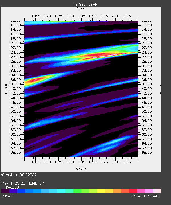
| Estimated Moho Depth: |
25.25 km |
| Estimated Crust Vp/Vs: |
1.96 |
| Assumed Crust Vp: |
6.276 km/s |
| Estimated Crust Vs: |
3.202 km/s |
| Estimated Crust Poisson's Ratio: |
0.32 |
|
| Radial Match: |
88.32837 % |
| Radial Bump: |
246 |
| Transverse Match: |
71.93558 % |
| Transverse Bump: |
400 |
| SOD ConfigId: |
17000 |
| Insert Time: |
2010-02-26 14:15:50.124 +0000 |
| GWidth: |
2.5 |
| Max Bumps: |
400 |
| Tol: |
0.001 |
|

Signal To Noise
| Channel | StoN | STA | LTA |
| TS:GSC: :BHN:19920905T21:54:36.833014Z | 1.2304702 | 9.894911E-8 | 8.041569E-8 |
| TS:GSC: :BHE:19920905T21:54:36.833014Z | 1.5038768 | 1.2682261E-7 | 8.433046E-8 |
| TS:GSC: :BHZ:19920905T21:54:36.833014Z | 5.133067 | 3.556826E-7 | 6.929242E-8 |
| Arrivals |
| Ps | 4.1 SECOND |
| PpPs | 11 SECOND |
| PsPs/PpSs | 15 SECOND |


