You are here: Home > Network List > NE - New England Seismic Network Stations List
> Station FFD Franklin Falls Dam, NH, USA > Earthquake Result Viewer
FFD Franklin Falls Dam, NH, USA - Earthquake Result Viewer
| Earthquake location: |
San Juan Province, Argentina |
| Earthquake latitude/longitude: |
-31.6/-68.8 |
| Earthquake time(UTC): |
2016/11/20 (325) 20:57:43 GMT |
| Earthquake Depth: |
116 km |
| Earthquake Magnitude: |
6.4 MWP, 6.5 MWB |
| Earthquake Catalog/Contributor: |
NEIC PDE/NEIC COMCAT |
|
| Network: |
NE New England Seismic Network |
| Station: |
FFD Franklin Falls Dam, NH, USA |
| Lat/Lon: |
43.47 N/71.65 W |
| Elevation: |
131 m |
|
| Distance: |
74.8 deg |
| Az: |
357.821 deg |
| Baz: |
177.447 deg |
| Ray Param: |
0.051817693 |
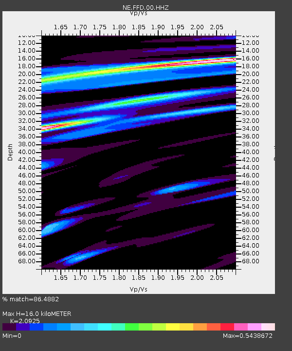
| Estimated Moho Depth: |
16.0 km |
| Estimated Crust Vp/Vs: |
2.09 |
| Assumed Crust Vp: |
6.419 km/s |
| Estimated Crust Vs: |
3.068 km/s |
| Estimated Crust Poisson's Ratio: |
0.35 |
|
| Radial Match: |
86.4882 % |
| Radial Bump: |
369 |
| Transverse Match: |
62.798584 % |
| Transverse Bump: |
400 |
| SOD ConfigId: |
1858631 |
| Insert Time: |
2016-12-04 21:03:03.725 +0000 |
| GWidth: |
2.5 |
| Max Bumps: |
400 |
| Tol: |
0.001 |
|

Signal To Noise
| Channel | StoN | STA | LTA |
| NE:FFD:00:HHZ:20161120T21:08:40.589009Z | 4.351587 | 4.253389E-6 | 9.774341E-7 |
| NE:FFD:00:HH1:20161120T21:08:40.589009Z | 2.5580285 | 1.9861118E-6 | 7.7642295E-7 |
| NE:FFD:00:HH2:20161120T21:08:40.589009Z | 2.087611 | 8.7033715E-7 | 4.1690583E-7 |
| Arrivals |
| Ps | 2.8 SECOND |
| PpPs | 7.5 SECOND |
| PsPs/PpSs | 10 SECOND |


