You are here: Home > Network List > NN - Western Great Basin/Eastern Sierra Nevada Stations List
> Station PRN Pahroc Range, Nevada. (GPS 12/04/2000) w84 > Earthquake Result Viewer
PRN Pahroc Range, Nevada. (GPS 12/04/2000) w84 - Earthquake Result Viewer
| Earthquake location: |
Kermadec Islands, New Zealand |
| Earthquake latitude/longitude: |
-30.8/-178.1 |
| Earthquake time(UTC): |
2019/06/15 (166) 22:55:02 GMT |
| Earthquake Depth: |
35 km |
| Earthquake Magnitude: |
7.4 Mwp |
| Earthquake Catalog/Contributor: |
NEIC PDE/us |
|
| Network: |
NN Western Great Basin/Eastern Sierra Nevada |
| Station: |
PRN Pahroc Range, Nevada. (GPS 12/04/2000) w84 |
| Lat/Lon: |
37.41 N/115.05 W |
| Elevation: |
1464 m |
|
| Distance: |
89.9 deg |
| Az: |
45.209 deg |
| Baz: |
230.06 deg |
| Ray Param: |
0.04171007 |
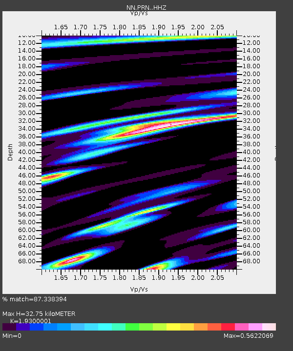
| Estimated Moho Depth: |
32.75 km |
| Estimated Crust Vp/Vs: |
1.93 |
| Assumed Crust Vp: |
6.276 km/s |
| Estimated Crust Vs: |
3.252 km/s |
| Estimated Crust Poisson's Ratio: |
0.32 |
|
| Radial Match: |
87.338394 % |
| Radial Bump: |
400 |
| Transverse Match: |
75.65508 % |
| Transverse Bump: |
400 |
| SOD ConfigId: |
18369291 |
| Insert Time: |
2019-06-29 23:07:03.034 +0000 |
| GWidth: |
2.5 |
| Max Bumps: |
400 |
| Tol: |
0.001 |
|

Signal To Noise
| Channel | StoN | STA | LTA |
| NN:PRN: :HHZ:20190615T23:07:26.259972Z | 5.459139 | 3.2684625E-6 | 5.9871394E-7 |
| NN:PRN: :HHN:20190615T23:07:26.259972Z | 4.1812615 | 8.827483E-7 | 2.111201E-7 |
| NN:PRN: :HHE:20190615T23:07:26.259972Z | 2.2165442 | 1.1058925E-6 | 4.989264E-7 |
| Arrivals |
| Ps | 4.9 SECOND |
| PpPs | 15 SECOND |
| PsPs/PpSs | 20 SECOND |


