You are here: Home > Network List > TA - USArray Transportable Network (new EarthScope stations) Stations List
> Station G19K Purcell Mountains, AK, USA > Earthquake Result Viewer
G19K Purcell Mountains, AK, USA - Earthquake Result Viewer
| Earthquake location: |
Kermadec Islands, New Zealand |
| Earthquake latitude/longitude: |
-30.8/-178.1 |
| Earthquake time(UTC): |
2019/06/15 (166) 22:55:02 GMT |
| Earthquake Depth: |
35 km |
| Earthquake Magnitude: |
7.4 Mwp |
| Earthquake Catalog/Contributor: |
NEIC PDE/us |
|
| Network: |
TA USArray Transportable Network (new EarthScope stations) |
| Station: |
G19K Purcell Mountains, AK, USA |
| Lat/Lon: |
66.14 N/157.09 W |
| Elevation: |
391 m |
|
| Distance: |
98.0 deg |
| Az: |
8.46 deg |
| Baz: |
198.131 deg |
| Ray Param: |
0.04002533 |
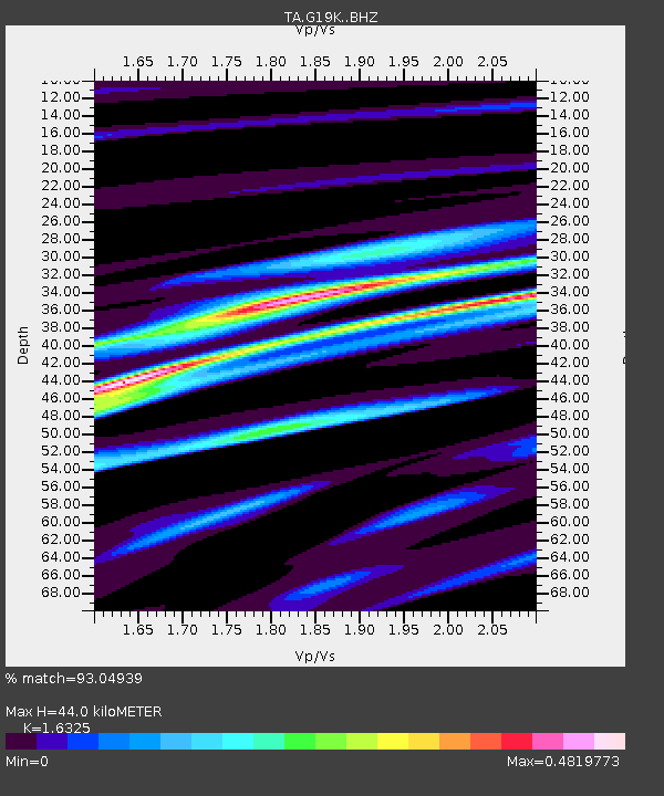
| Estimated Moho Depth: |
44.0 km |
| Estimated Crust Vp/Vs: |
1.63 |
| Assumed Crust Vp: |
6.577 km/s |
| Estimated Crust Vs: |
4.029 km/s |
| Estimated Crust Poisson's Ratio: |
0.20 |
|
| Radial Match: |
93.04939 % |
| Radial Bump: |
400 |
| Transverse Match: |
88.18754 % |
| Transverse Bump: |
400 |
| SOD ConfigId: |
18369291 |
| Insert Time: |
2019-06-29 23:08:03.275 +0000 |
| GWidth: |
2.5 |
| Max Bumps: |
400 |
| Tol: |
0.001 |
|

Signal To Noise
| Channel | StoN | STA | LTA |
| TA:G19K: :BHZ:20190615T23:08:03.300011Z | 9.852066 | 1.9927968E-6 | 2.0227196E-7 |
| TA:G19K: :BHN:20190615T23:08:03.300011Z | 3.4509997 | 7.0949045E-7 | 2.0558983E-7 |
| TA:G19K: :BHE:20190615T23:08:03.300011Z | 3.6802473 | 4.7181427E-7 | 1.2820178E-7 |
| Arrivals |
| Ps | 4.3 SECOND |
| PpPs | 17 SECOND |
| PsPs/PpSs | 22 SECOND |


