You are here: Home > Network List > TA - USArray Transportable Network (new EarthScope stations) Stations List
> Station J20K Nowitna River, AK, USA > Earthquake Result Viewer
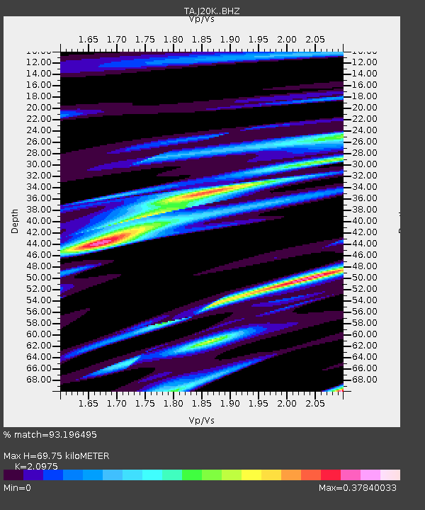
J20K Nowitna River, AK, USA - Earthquake Result Viewer
| Earthquake location: |
Kermadec Islands, New Zealand |
| Earthquake latitude/longitude: |
-30.8/-178.1 |
| Earthquake time(UTC): |
2019/06/15 (166) 22:55:02 GMT |
| Earthquake Depth: |
35 km |
| Earthquake Magnitude: |
7.4 Mwp |
| Earthquake Catalog/Contributor: |
NEIC PDE/us |
|
| Network: |
TA USArray Transportable Network (new EarthScope stations) |
| Station: |
J20K Nowitna River, AK, USA |
| Lat/Lon: |
64.18 N/154.15 W |
| Elevation: |
314 m |
|
| Distance: |
96.5 deg |
| Az: |
10.301 deg |
| Baz: |
200.563 deg |
| Ray Param: |
0.040467843 |
| Estimated Moho Depth: |
69.75 km |
| Estimated Crust Vp/Vs: |
2.10 |
| Assumed Crust Vp: |
6.566 km/s |
| Estimated Crust Vs: |
3.13 km/s |
| Estimated Crust Poisson's Ratio: |
0.35 |
|
| Radial Match: |
93.196495 % |
| Radial Bump: |
400 |
| Transverse Match: |
87.07915 % |
| Transverse Bump: |
400 |
| SOD ConfigId: |
18369291 |
| Insert Time: |
2019-06-29 23:08:12.485 +0000 |
| GWidth: |
2.5 |
| Max Bumps: |
400 |
| Tol: |
0.001 |
|

Signal To Noise
| Channel | StoN | STA | LTA |
| TA:J20K: :BHZ:20190615T23:07:56.800011Z | 10.796948 | 2.5561815E-6 | 2.3675035E-7 |
| TA:J20K: :BHN:20190615T23:07:56.800011Z | 4.165874 | 8.8866324E-7 | 2.1331977E-7 |
| TA:J20K: :BHE:20190615T23:07:56.800011Z | 1.9347576 | 2.2319844E-7 | 1.1536248E-7 |
| Arrivals |
| Ps | 12 SECOND |
| PpPs | 32 SECOND |
| PsPs/PpSs | 44 SECOND |


