You are here: Home > Network List > TA - USArray Transportable Network (new EarthScope stations) Stations List
> Station L20K Farewell, AK, USA > Earthquake Result Viewer
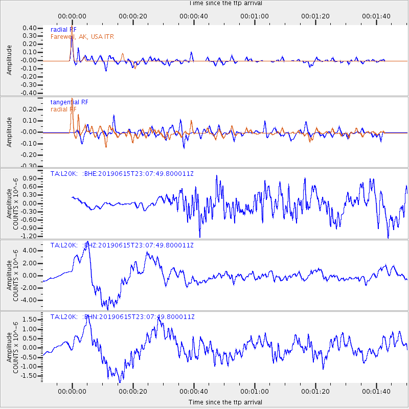
L20K Farewell, AK, USA - Earthquake Result Viewer
| Earthquake location: |
Kermadec Islands, New Zealand |
| Earthquake latitude/longitude: |
-30.8/-178.1 |
| Earthquake time(UTC): |
2019/06/15 (166) 22:55:02 GMT |
| Earthquake Depth: |
35 km |
| Earthquake Magnitude: |
7.4 Mwp |
| Earthquake Catalog/Contributor: |
NEIC PDE/us |
|
| Network: |
TA USArray Transportable Network (new EarthScope stations) |
| Station: |
L20K Farewell, AK, USA |
| Lat/Lon: |
62.48 N/153.88 W |
| Elevation: |
673 m |
|
| Distance: |
95.0 deg |
| Az: |
11.018 deg |
| Baz: |
200.73 deg |
| Ray Param: |
0.040886723 |
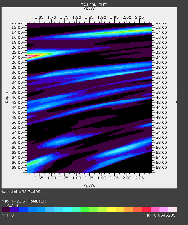
| Estimated Moho Depth: |
23.5 km |
| Estimated Crust Vp/Vs: |
1.60 |
| Assumed Crust Vp: |
6.566 km/s |
| Estimated Crust Vs: |
4.104 km/s |
| Estimated Crust Poisson's Ratio: |
0.18 |
|
| Radial Match: |
93.74409 % |
| Radial Bump: |
400 |
| Transverse Match: |
81.897026 % |
| Transverse Bump: |
400 |
| SOD ConfigId: |
18369291 |
| Insert Time: |
2019-06-29 23:08:20.201 +0000 |
| GWidth: |
2.5 |
| Max Bumps: |
400 |
| Tol: |
0.001 |
|
Signal To Noise
| Channel | StoN | STA | LTA |
| TA:L20K: :BHZ:20190615T23:07:49.800011Z | 11.693176 | 3.1943118E-6 | 2.7317742E-7 |
| TA:L20K: :BHN:20190615T23:07:49.800011Z | 6.240964 | 7.6189394E-7 | 1.2207954E-7 |
| TA:L20K: :BHE:20190615T23:07:49.800011Z | 1.9315326 | 2.1127079E-7 | 1.0937987E-7 |
| Arrivals |
| Ps | 2.2 SECOND |
| PpPs | 9.1 SECOND |
| PsPs/PpSs | 11 SECOND |


