You are here: Home > Network List > TA - USArray Transportable Network (new EarthScope stations) Stations List
> Station Q16K King Salmon, AK, USA > Earthquake Result Viewer
Q16K King Salmon, AK, USA - Earthquake Result Viewer
| Earthquake location: |
Kermadec Islands, New Zealand |
| Earthquake latitude/longitude: |
-30.8/-178.1 |
| Earthquake time(UTC): |
2019/06/15 (166) 22:55:02 GMT |
| Earthquake Depth: |
35 km |
| Earthquake Magnitude: |
7.4 Mwp |
| Earthquake Catalog/Contributor: |
NEIC PDE/us |
|
| Network: |
TA USArray Transportable Network (new EarthScope stations) |
| Station: |
Q16K King Salmon, AK, USA |
| Lat/Lon: |
58.68 N/156.66 W |
| Elevation: |
22 m |
|
| Distance: |
90.9 deg |
| Az: |
11.0 deg |
| Baz: |
198.315 deg |
| Ray Param: |
0.04163373 |
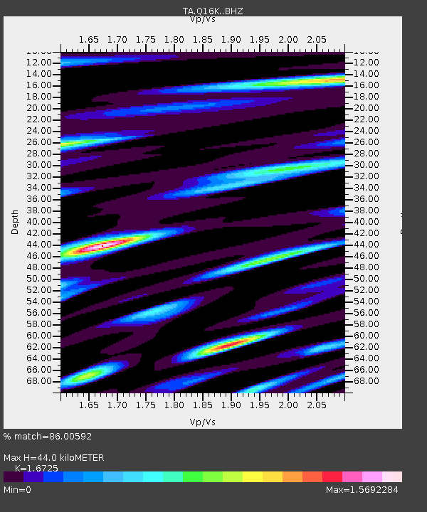
| Estimated Moho Depth: |
44.0 km |
| Estimated Crust Vp/Vs: |
1.67 |
| Assumed Crust Vp: |
6.276 km/s |
| Estimated Crust Vs: |
3.752 km/s |
| Estimated Crust Poisson's Ratio: |
0.22 |
|
| Radial Match: |
86.00592 % |
| Radial Bump: |
400 |
| Transverse Match: |
79.664566 % |
| Transverse Bump: |
400 |
| SOD ConfigId: |
18369291 |
| Insert Time: |
2019-06-29 23:08:50.646 +0000 |
| GWidth: |
2.5 |
| Max Bumps: |
400 |
| Tol: |
0.001 |
|

Signal To Noise
| Channel | StoN | STA | LTA |
| TA:Q16K: :BHZ:20190615T23:07:31.224999Z | 18.127012 | 5.890856E-6 | 3.2497667E-7 |
| TA:Q16K: :BHN:20190615T23:07:31.224999Z | 5.5978966 | 2.5208662E-6 | 4.5032385E-7 |
| TA:Q16K: :BHE:20190615T23:07:31.224999Z | 2.2195284 | 8.523499E-7 | 3.84023E-7 |
| Arrivals |
| Ps | 4.8 SECOND |
| PpPs | 18 SECOND |
| PsPs/PpSs | 23 SECOND |


