You are here: Home > Network List > NM - Cooperative New Madrid Seismic Network Stations List
> Station PEBM Pemiscot Bayou,MO > Earthquake Result Viewer
PEBM Pemiscot Bayou,MO - Earthquake Result Viewer
| Earthquake location: |
San Juan Province, Argentina |
| Earthquake latitude/longitude: |
-31.6/-68.8 |
| Earthquake time(UTC): |
2016/11/20 (325) 20:57:43 GMT |
| Earthquake Depth: |
116 km |
| Earthquake Magnitude: |
6.4 MWP, 6.5 MWB |
| Earthquake Catalog/Contributor: |
NEIC PDE/NEIC COMCAT |
|
| Network: |
NM Cooperative New Madrid Seismic Network |
| Station: |
PEBM Pemiscot Bayou,MO |
| Lat/Lon: |
36.11 N/89.86 W |
| Elevation: |
76 m |
|
| Distance: |
70.2 deg |
| Az: |
341.959 deg |
| Baz: |
160.961 deg |
| Ray Param: |
0.0548127 |
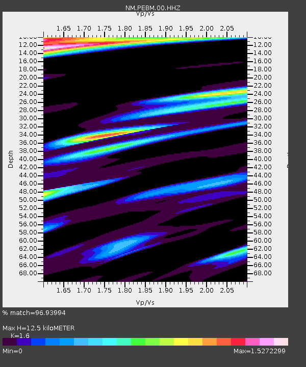
| Estimated Moho Depth: |
12.5 km |
| Estimated Crust Vp/Vs: |
1.60 |
| Assumed Crust Vp: |
6.444 km/s |
| Estimated Crust Vs: |
4.027 km/s |
| Estimated Crust Poisson's Ratio: |
0.18 |
|
| Radial Match: |
96.93994 % |
| Radial Bump: |
361 |
| Transverse Match: |
81.651924 % |
| Transverse Bump: |
400 |
| SOD ConfigId: |
1858631 |
| Insert Time: |
2016-12-04 21:03:41.258 +0000 |
| GWidth: |
2.5 |
| Max Bumps: |
400 |
| Tol: |
0.001 |
|

Signal To Noise
| Channel | StoN | STA | LTA |
| NM:PEBM:00:HHZ:20161120T21:08:13.699971Z | 51.142956 | 1.4317006E-5 | 2.7994093E-7 |
| NM:PEBM:00:HHN:20161120T21:08:13.699971Z | 7.166421 | 5.848804E-6 | 8.161402E-7 |
| NM:PEBM:00:HHE:20161120T21:08:13.699971Z | 4.7813053 | 3.3116387E-6 | 6.9262234E-7 |
| Arrivals |
| Ps | 1.2 SECOND |
| PpPs | 4.8 SECOND |
| PsPs/PpSs | 6.1 SECOND |


