You are here: Home > Network List > TS - TERRAscope (Southern California Seismic Network) Stations List
> Station GSC Goldston, California, USA > Earthquake Result Viewer
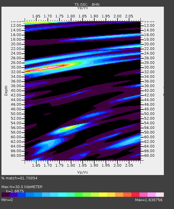
GSC Goldston, California, USA - Earthquake Result Viewer
| Earthquake location: |
Andreanof Islands, Aleutian Is. |
| Earthquake latitude/longitude: |
51.1/-177.8 |
| Earthquake time(UTC): |
1992/10/08 (282) 16:34:56 GMT |
| Earthquake Depth: |
43 km |
| Earthquake Magnitude: |
5.6 MB, 5.7 MS, 5.4 ML |
| Earthquake Catalog/Contributor: |
WHDF/NEIC |
|
| Network: |
TS TERRAscope (Southern California Seismic Network) |
| Station: |
GSC Goldston, California, USA |
| Lat/Lon: |
35.30 N/116.81 W |
| Elevation: |
990 m |
|
| Distance: |
45.9 deg |
| Az: |
85.629 deg |
| Baz: |
309.832 deg |
| Ray Param: |
0.07090159 |
| Estimated Moho Depth: |
30.0 km |
| Estimated Crust Vp/Vs: |
1.70 |
| Assumed Crust Vp: |
6.276 km/s |
| Estimated Crust Vs: |
3.697 km/s |
| Estimated Crust Poisson's Ratio: |
0.23 |
|
| Radial Match: |
81.70854 % |
| Radial Bump: |
394 |
| Transverse Match: |
74.51595 % |
| Transverse Bump: |
400 |
| SOD ConfigId: |
17000 |
| Insert Time: |
2010-02-26 14:15:54.943 +0000 |
| GWidth: |
2.5 |
| Max Bumps: |
400 |
| Tol: |
0.001 |
|

Signal To Noise
| Channel | StoN | STA | LTA |
| TS:GSC: :BHN:19921008T16:42:43.515991Z | 1.529586 | 2.0281657E-7 | 1.3259573E-7 |
| TS:GSC: :BHE:19921008T16:42:43.515991Z | 0.94247043 | 1.0921255E-7 | 1.1587902E-7 |
| TS:GSC: :BHZ:19921008T16:42:43.515991Z | 2.7203693 | 2.7831723E-7 | 1.0230861E-7 |
| Arrivals |
| Ps | 3.5 SECOND |
| PpPs | 12 SECOND |
| PsPs/PpSs | 16 SECOND |


