You are here: Home > Network List > TA - USArray Transportable Network (new EarthScope stations) Stations List
> Station V24A Rampart Ranch, Las Vegas, NM, USA > Earthquake Result Viewer
V24A Rampart Ranch, Las Vegas, NM, USA - Earthquake Result Viewer
| Earthquake location: |
Off East Coast Of Honshu, Japan |
| Earthquake latitude/longitude: |
37.2/142.1 |
| Earthquake time(UTC): |
2008/07/21 (203) 11:30:29 GMT |
| Earthquake Depth: |
22 km |
| Earthquake Magnitude: |
5.7 MB, 5.6 MS, 6.0 MW, 5.9 MW |
| Earthquake Catalog/Contributor: |
WHDF/NEIC |
|
| Network: |
TA USArray Transportable Network (new EarthScope stations) |
| Station: |
V24A Rampart Ranch, Las Vegas, NM, USA |
| Lat/Lon: |
35.73 N/105.27 W |
| Elevation: |
2187 m |
|
| Distance: |
84.3 deg |
| Az: |
48.982 deg |
| Baz: |
312.222 deg |
| Ray Param: |
0.04556068 |
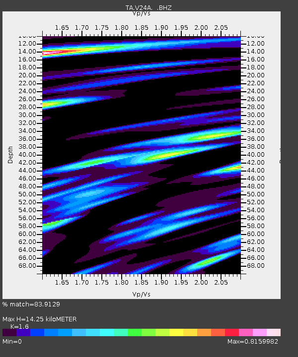
| Estimated Moho Depth: |
14.25 km |
| Estimated Crust Vp/Vs: |
1.60 |
| Assumed Crust Vp: |
6.419 km/s |
| Estimated Crust Vs: |
4.012 km/s |
| Estimated Crust Poisson's Ratio: |
0.18 |
|
| Radial Match: |
83.9129 % |
| Radial Bump: |
336 |
| Transverse Match: |
62.621887 % |
| Transverse Bump: |
356 |
| SOD ConfigId: |
2504 |
| Insert Time: |
2010-03-06 23:46:13.443 +0000 |
| GWidth: |
2.5 |
| Max Bumps: |
400 |
| Tol: |
0.001 |
|
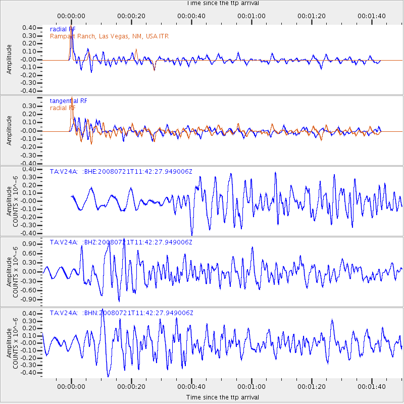
Signal To Noise
| Channel | StoN | STA | LTA |
| TA:V24A: :BHZ:20080721T11:42:27.949006Z | 3.6173425 | 3.1151956E-7 | 8.611835E-8 |
| TA:V24A: :BHN:20080721T11:42:27.949006Z | 0.8982915 | 8.9662336E-8 | 9.981429E-8 |
| TA:V24A: :BHE:20080721T11:42:27.949006Z | 0.7300819 | 5.6435812E-8 | 7.7300655E-8 |
| Arrivals |
| Ps | 1.4 SECOND |
| PpPs | 5.6 SECOND |
| PsPs/PpSs | 7.0 SECOND |


