You are here: Home > Network List > TA - USArray Transportable Network (new EarthScope stations) Stations List
> Station U33K Whale Pass, AK, USA > Earthquake Result Viewer
U33K Whale Pass, AK, USA - Earthquake Result Viewer

| Earthquake location: |
Kermadec Islands, New Zealand |
| Earthquake latitude/longitude: |
-30.8/-178.1 |
| Earthquake time(UTC): |
2019/06/15 (166) 22:55:02 GMT |
| Earthquake Depth: |
35 km |
| Earthquake Magnitude: |
7.4 Mwp |
| Earthquake Catalog/Contributor: |
NEIC PDE/us |
|
| Network: |
TA USArray Transportable Network (new EarthScope stations) |
| Station: |
U33K Whale Pass, AK, USA |
| Lat/Lon: |
56.11 N/133.12 W |
| Elevation: |
11 m |
|
| Distance: |
94.7 deg |
| Az: |
23.395 deg |
| Baz: |
217.581 deg |
| Ray Param: |
0.040972322 |
| Estimated Moho Depth: |
31.0 km |
| Estimated Crust Vp/Vs: |
1.87 |
| Assumed Crust Vp: |
6.597 km/s |
| Estimated Crust Vs: |
3.528 km/s |
| Estimated Crust Poisson's Ratio: |
0.30 |
|
| Radial Match: |
90.95416 % |
| Radial Bump: |
400 |
| Transverse Match: |
72.8653 % |
| Transverse Bump: |
400 |
| SOD ConfigId: |
18369291 |
| Insert Time: |
2019-06-29 23:09:03.443 +0000 |
| GWidth: |
2.5 |
| Max Bumps: |
400 |
| Tol: |
0.001 |
|
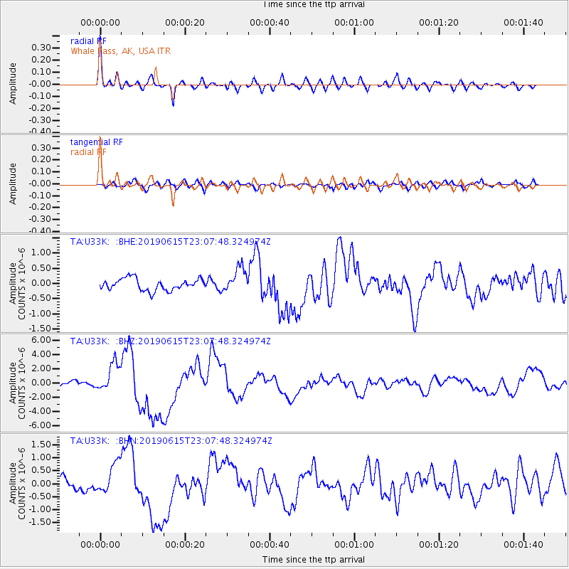
Signal To Noise
| Channel | StoN | STA | LTA |
| TA:U33K: :BHZ:20190615T23:07:48.324974Z | 3.8937736 | 2.1724347E-6 | 5.5792526E-7 |
| TA:U33K: :BHN:20190615T23:07:48.324974Z | 2.228429 | 6.051571E-7 | 2.715622E-7 |
| TA:U33K: :BHE:20190615T23:07:48.324974Z | 2.171765 | 4.1708833E-7 | 1.920504E-7 |
| Arrivals |
| Ps | 4.2 SECOND |
| PpPs | 13 SECOND |
| PsPs/PpSs | 17 SECOND |


