You are here: Home > Network List > NM - Cooperative New Madrid Seismic Network Stations List
> Station X601 Temporary Arkansas > Earthquake Result Viewer
X601 Temporary Arkansas - Earthquake Result Viewer
| Earthquake location: |
San Juan Province, Argentina |
| Earthquake latitude/longitude: |
-31.6/-68.8 |
| Earthquake time(UTC): |
2016/11/20 (325) 20:57:43 GMT |
| Earthquake Depth: |
116 km |
| Earthquake Magnitude: |
6.4 MWP, 6.5 MWB |
| Earthquake Catalog/Contributor: |
NEIC PDE/NEIC COMCAT |
|
| Network: |
NM Cooperative New Madrid Seismic Network |
| Station: |
X601 Temporary Arkansas |
| Lat/Lon: |
35.40 N/92.47 W |
| Elevation: |
206 m |
|
| Distance: |
70.3 deg |
| Az: |
339.584 deg |
| Baz: |
158.642 deg |
| Ray Param: |
0.054769214 |
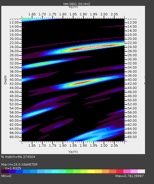
| Estimated Moho Depth: |
24.0 km |
| Estimated Crust Vp/Vs: |
1.93 |
| Assumed Crust Vp: |
6.498 km/s |
| Estimated Crust Vs: |
3.362 km/s |
| Estimated Crust Poisson's Ratio: |
0.32 |
|
| Radial Match: |
96.374504 % |
| Radial Bump: |
375 |
| Transverse Match: |
88.6553 % |
| Transverse Bump: |
400 |
| SOD ConfigId: |
1858631 |
| Insert Time: |
2016-12-04 21:03:53.099 +0000 |
| GWidth: |
2.5 |
| Max Bumps: |
400 |
| Tol: |
0.001 |
|

Signal To Noise
| Channel | StoN | STA | LTA |
| NM:X601:00:HHZ:20161120T21:08:14.099995Z | 28.356413 | 8.10891E-6 | 2.859639E-7 |
| NM:X601:00:HHN:20161120T21:08:14.099995Z | 9.286889 | 4.121345E-6 | 4.43781E-7 |
| NM:X601:00:HHE:20161120T21:08:14.099995Z | 4.8735223 | 1.5949404E-6 | 3.2726646E-7 |
| Arrivals |
| Ps | 3.6 SECOND |
| PpPs | 10 SECOND |
| PsPs/PpSs | 14 SECOND |


