You are here: Home > Network List > UO - University of Oregon Regional Network Stations List
> Station DFAZ Toketee, OR, USA > Earthquake Result Viewer
DFAZ Toketee, OR, USA - Earthquake Result Viewer
| Earthquake location: |
Kermadec Islands, New Zealand |
| Earthquake latitude/longitude: |
-30.8/-178.1 |
| Earthquake time(UTC): |
2019/06/15 (166) 22:55:02 GMT |
| Earthquake Depth: |
35 km |
| Earthquake Magnitude: |
7.4 Mwp |
| Earthquake Catalog/Contributor: |
NEIC PDE/us |
|
| Network: |
UO University of Oregon Regional Network |
| Station: |
DFAZ Toketee, OR, USA |
| Lat/Lon: |
43.24 N/122.11 W |
| Elevation: |
1948 m |
|
| Distance: |
89.8 deg |
| Az: |
37.273 deg |
| Baz: |
225.477 deg |
| Ray Param: |
0.04171616 |
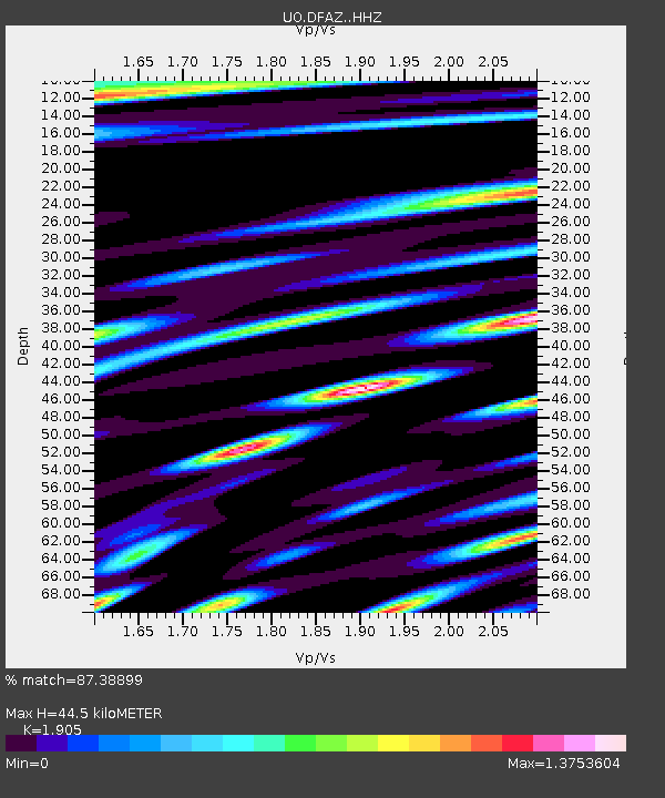
| Estimated Moho Depth: |
44.5 km |
| Estimated Crust Vp/Vs: |
1.90 |
| Assumed Crust Vp: |
6.522 km/s |
| Estimated Crust Vs: |
3.423 km/s |
| Estimated Crust Poisson's Ratio: |
0.31 |
|
| Radial Match: |
87.38899 % |
| Radial Bump: |
400 |
| Transverse Match: |
85.64691 % |
| Transverse Bump: |
400 |
| SOD ConfigId: |
18369291 |
| Insert Time: |
2019-06-29 23:09:37.987 +0000 |
| GWidth: |
2.5 |
| Max Bumps: |
400 |
| Tol: |
0.001 |
|

Signal To Noise
| Channel | StoN | STA | LTA |
| UO:DFAZ: :HHZ:20190615T23:07:25.857994Z | 17.9011 | 3.9466813E-6 | 2.2047143E-7 |
| UO:DFAZ: :HHN:20190615T23:07:25.857994Z | 2.9232442 | 9.328901E-7 | 3.1912833E-7 |
| UO:DFAZ: :HHE:20190615T23:07:25.857994Z | 3.9253542 | 1.6643592E-6 | 4.2400228E-7 |
| Arrivals |
| Ps | 6.3 SECOND |
| PpPs | 19 SECOND |
| PsPs/PpSs | 26 SECOND |


