You are here: Home > Network List > UO - University of Oregon Regional Network Stations List
> Station DING Powers, OR, USA > Earthquake Result Viewer
DING Powers, OR, USA - Earthquake Result Viewer
| Earthquake location: |
Kermadec Islands, New Zealand |
| Earthquake latitude/longitude: |
-30.8/-178.1 |
| Earthquake time(UTC): |
2019/06/15 (166) 22:55:02 GMT |
| Earthquake Depth: |
35 km |
| Earthquake Magnitude: |
7.4 Mwp |
| Earthquake Catalog/Contributor: |
NEIC PDE/us |
|
| Network: |
UO University of Oregon Regional Network |
| Station: |
DING Powers, OR, USA |
| Lat/Lon: |
42.86 N/124.05 W |
| Elevation: |
100 m |
|
| Distance: |
88.5 deg |
| Az: |
36.528 deg |
| Baz: |
224.143 deg |
| Ray Param: |
0.042491313 |
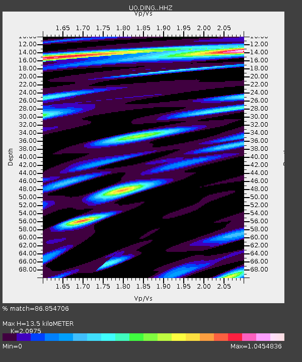
| Estimated Moho Depth: |
13.5 km |
| Estimated Crust Vp/Vs: |
2.10 |
| Assumed Crust Vp: |
6.048 km/s |
| Estimated Crust Vs: |
2.883 km/s |
| Estimated Crust Poisson's Ratio: |
0.35 |
|
| Radial Match: |
86.854706 % |
| Radial Bump: |
400 |
| Transverse Match: |
68.627335 % |
| Transverse Bump: |
400 |
| SOD ConfigId: |
18369291 |
| Insert Time: |
2019-06-29 23:09:38.227 +0000 |
| GWidth: |
2.5 |
| Max Bumps: |
400 |
| Tol: |
0.001 |
|

Signal To Noise
| Channel | StoN | STA | LTA |
| UO:DING: :HHZ:20190615T23:07:19.920006Z | 7.166299 | 3.5670198E-6 | 4.977492E-7 |
| UO:DING: :HHN:20190615T23:07:19.920006Z | 2.5857818 | 8.054236E-7 | 3.1148167E-7 |
| UO:DING: :HHE:20190615T23:07:19.920006Z | 1.4683113 | 9.699057E-7 | 6.605586E-7 |
| Arrivals |
| Ps | 2.5 SECOND |
| PpPs | 6.8 SECOND |
| PsPs/PpSs | 9.3 SECOND |


